Carroll County | |
|---|---|
 Carroll County Courthouse in Berryville | |
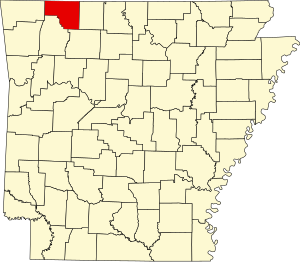
 Location within the U.S. state of Arkansas | |
 Arkansas's location within the U.S. | |
| Coordinates: 36°22′05″N 93°29′47″W / 36.368055555556°N 93.496388888889°W | |
| Country | |
| State | |
| Founded | November 1, 1833 |
| Named for | Charles Carroll |
| Seat | Berryville and Eureka Springs |
| Largest city | Berryville |
| Area | |
• Total | 639 sq mi (1,660 km2) |
| • Land | 630 sq mi (1,600 km2) |
| • Water | 8.7 sq mi (23 km2) 1.4% |
| Population (2020) | |
• Total | 28,260 |
| • Density | 44/sq mi (17/km2) |
| Time zone | UTC−6 (Central) |
| • Summer (DST) | UTC−5 (CDT) |
| Area code | 479 (Eureka Springs) 870 (Berryville) |
| Congressional district | 3rd |
| Website | carrollcounty |

Carroll County is a county located in the U.S. state of Arkansas. As of the 2020 census, the population was 28,260.[1] The county has two county seats, Berryville and Eureka Springs.[2] Carroll County is Arkansas's 26th county, formed on November 1, 1833, and named after Charles Carroll,[3] the last surviving signer of the United States Declaration of Independence.
- ^ "Explore Census Data". data.census.gov. Retrieved December 21, 2021.
- ^ "Find a County". National Association of Counties. Archived from the original on May 31, 2011. Retrieved June 7, 2011.
- ^ Gannett, Henry (1905). The Origin of Certain Place Names in the United States. Govt. Print. Off. pp. 70.