Carroll County | |
|---|---|
 Carroll County Courthouse in Westminster | |
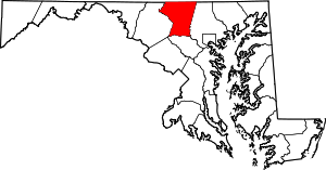
 Location within the U.S. state of Maryland | |
 Maryland's location within the U.S. | |
| Coordinates: 39°34′N 77°01′W / 39.57°N 77.02°W | |
| Country | |
| State | |
| Founded | January 19, 1837 |
| Named for | Charles Carroll of Carrollton |
| Seat | Westminster |
| Largest community | Eldersburg |
| Area | |
| • Total | 453 sq mi (1,170 km2) |
| • Land | 448 sq mi (1,160 km2) |
| • Water | 5.1 sq mi (13 km2) 1.1% |
| Population (2020) | |
| • Total | 172,891 |
| • Estimate (2023) | 176,639 |
| • Density | 380/sq mi (150/km2) |
| Time zone | UTC−5 (Eastern) |
| • Summer (DST) | UTC−4 (EDT) |
| Congressional districts | 2nd, 3rd |
| Website | carrollcountymd |
Carroll County is a county located in the U.S. state of Maryland. As of the 2020 census, the population was 172,891.[1] Its county seat is Westminster.[2] The county is part of the Central Maryland region of the state. Carroll County is included in the Washington-Baltimore-Arlington, DC-MD-VA-WV-PA Combined Statistical Area. While predominantly rural, the county has become increasingly suburban in recent years.
- ^ "Carroll County, Maryland". United States Census Bureau. Retrieved January 30, 2022.
- ^ "Find a County". National Association of Counties. Archived from the original on May 31, 2011. Retrieved June 7, 2011.

