Carson Sink | |
|---|---|
 View southeast across the Carson Sink from Topog Peak in the West Humboldt Range | |
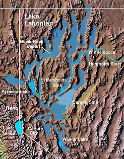
 The Carson Sink and the Lahontan Valley form the central portion of the lake bed of the prehistoric Lake Lahontan. | |
| Coordinates: 39°52′40″N 118°20′50″W / 39.87778°N 118.34722°W | |
| Location | Lahontan Basin, Nevada |
| Area | |
| • Total | 300 sq mi (780 km2) |
Carson Sink is a playa in the northeastern portion of the Carson Desert in present-day Nevada, United States of America, that was formerly the terminus of the Carson River. Today the sink is fed by drainage canals of the Truckee-Carson Irrigation District. The southeastern fringe of the sink, where the canals enter, is a wetland of the Central Basin and Range ecoregion.[1]
This is mostly included within the Fallon National Wildlife Refuge and the Stillwater Wildlife Management Area. This area serves as an important stopover for migrating waterfowl. The Sehoo Formation is south of the Carson Sink.[2]
- ^ Bryce, S.A; et al., Ecoregions of Nevada (PDF) (poster), Reston, Virginia: USGS, retrieved January 12, 2020
- ^ Morrison, R. B; Fry, John C (1965). "Correlation of the Middle and Late Quaternary Successions of the Lake Lahontan, Lake Bonneville, Rocky Mountain (Wasatch Range), Southern Great Plains, and Eastern Midwest Areas" (PDF). Nevada Bureau of Mines. Archived from the original (PDF) on 2010-06-06. Retrieved 2010-11-24.