Cartwright
Natsitok[1] | |
|---|---|
Town | |
 | |
| Coordinates: 53°42′24″N 57°01′11″W / 53.70667°N 57.01972°W | |
| Country | Canada |
| Province | Newfoundland and Labrador |
| Settled | 1775 |
| Incorporated | 1956 |
| Government | |
| • Mayor | Robyn Holwell |
| Area | |
| • Land | 3.27 km2 (1.26 sq mi) |
| Elevation | 10 m (30 ft) |
| Population (2021) | |
• Total | 439 |
| Time zone | UTC−04:00 (AST) |
| • Summer (DST) | UTC−03:00 (ADT) |
| Area code | 709 |
| Highways | |
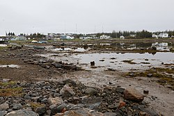
Cartwright is a community located on the eastern side of the entrance to Sandwich Bay, along the southern coast of Labrador in the province of Newfoundland and Labrador, Canada. It was incorporated in 1956.
Sandwich Bay is an area with a longstanding Inuit presence known to resident Inuit as Natsiktok or place of the ring seals. Archeological evidence, especially that excavated by Dr. Lisa Rankin indicates an early and year round Inuit presence.
Cartwright has been a settled community since 1775. In 1775, Captain George Cartwright, for whom the place is named, settled there, establishing a fish and fur trading business. He left Labrador in 1786, maintaining a business interest there until it was sold to Hunt and Henley in 1815. It was again sold in 1873 to the Hudson's Bay Company and has remained under company ownership ever since. The residents of Sandwich Bay (including Cartwright) were described by Rev. Bishop Field in 1848 as either 'pure Esquimaux' or 'Anglo-Esquimaux, with an admixture of old English settlers'.
Since 2002, Cartwright has been connected by road (a section of the Trans-Labrador Highway, Route 516) with Blanc Sablon, Quebec, where there is a car ferry to Newfoundland.[2] Since December 2009 the remaining link between Cartwright and Happy Valley-Goose Bay, Labrador has been completed and open to the public.[3][4][5]
- ^ "Toponymic and Cartographic Research Conducted for the Labrador Métis Nation" (PDF). mun.ca/. Archived from the original (PDF) on 2018-01-04. Retrieved 2017-08-25.
- ^ Ferry route Archived 2012-07-22 at the Wayback Machine
- ^ Barker, Jacob (19 April 2017). "'It's brutal': South coast Labrador sounds off on leg of Trans-Labrador Highway". CBC News.
- ^ "Ministerial Statement - Trans Labrador Highway Phase III Now Open Connecting Labrador West, Through Lake Melville, to Southern Labrador".
- ^ "Labrador Ride - Rock to RoadRock to Road". 28 September 2015.
