Caruthersville, Missouri | |
|---|---|
 Ward Avenue downtown | |
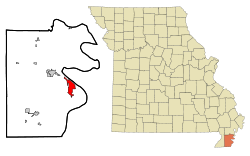
 Location within Pemiscot County and Missouri | |
| Coordinates: 36°10′53″N 89°39′59″W / 36.18139°N 89.66639°W | |
| Country | United States |
| State | Missouri |
| County | Pemiscot |
| Incorporated | May 18, 1874 |
| Named for | Samuel Caruthers (U.S. Congressman) |
| Government | |
| • Mayor | Sue Grantham (2023) |
| Area | |
• Total | 5.24 sq mi (13.56 km2) |
| • Land | 5.16 sq mi (13.36 km2) |
| • Water | 0.08 sq mi (0.20 km2) |
| Elevation | 269 ft (82 m) |
| Population (2020) | |
• Total | 5,562 |
| • Density | 1,078.32/sq mi (416.37/km2) |
| Time zone | UTC-6 (Central (CST)) |
| • Summer (DST) | UTC-5 (CDT) |
| ZIP code | 63830 |
| Area code | 573 |
| FIPS code | 29-11692[3] |
| GNIS feature ID | 2393761[2] |
| Website | www |
Caruthersville is a city in and the county seat of Pemiscot County, Missouri, United States, located along the Mississippi River in the Bootheel region of the state's far southeast. The population was 5,562, according to the 2020 census.[4]
- ^ "ArcGIS REST Services Directory". United States Census Bureau. Retrieved August 28, 2022.
- ^ a b U.S. Geological Survey Geographic Names Information System: Caruthersville, Missouri
- ^ "U.S. Census website". United States Census Bureau. Retrieved January 31, 2008.
- ^ "Explore Census Data". data.census.gov. Retrieved December 12, 2021.