| Cascades | |
|---|---|
 Scattered patches of subalpine fir grow below glaciers and permanent snowfields on the south slope of Mount Rainier in ecoregion 4d. | |
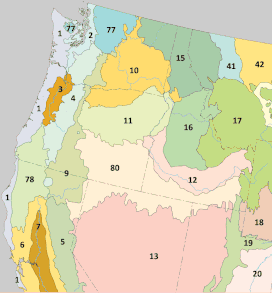
 Level III ecoregions of the Pacific Northwest. The Cascades ecoregion is marked with (4). | |
| Ecology | |
| Realm | Nearctic |
| Biome | Temperate coniferous forests |
| Borders | |
| Geography | |
| Area | 44,952 km2 (17,356 sq mi) |
| Country | United States |
| States | |
| Coordinates | 45°N 122°W / 45°N 122°W |
The Cascades ecoregion is a Level III ecoregion designated by the United States Environmental Protection Agency (EPA) in the U.S. states of Washington, Oregon, and California. Somewhat smaller than the Cascade mountain range for which it is named, the ecoregion extends north to Snoqualmie Pass, near Seattle, and south to Hayden Pass, near the Oregon-California border, including the peaks and western slopes of most of the High Cascades. A discontiguous section is located on Mount Shasta in California.
The mountainous region is underlain by Cenozoic volcanic rock that has been affected by alpine glaciations. The eastern part of the region contains active and dormant volcanoes in the Cascades Volcanic Arc, with elevations of up to 14,411 feet (4,392 m). The western Cascades are older, lower, and dissected by numerous, steep-sided stream valleys. The region has a moist, temperate climate, which supports an extensive and highly productive coniferous forest that is intensively managed for logging, as well as recreational use. Subalpine meadows occur at higher elevations.
Much of the region consists of public lands managed by the federal government, including the Mount Baker-Snoqualmie, Wenatchee, Gifford Pinchot, Mount Hood, Columbia River Gorge National Scenic Area, Willamette, Umpqua, and Rogue River National Forests; the Clearwater, Norse Peak, Tatoosh, William O. Douglas, Goat Rocks, Mount Adams, Indian Heaven, Trapper Creek, Salmon–Huckleberry, Mount Hood, Table Rock, Bull of the Woods, Opal Creek, Middle Santiam, Menagerie, Mount Jefferson, Mount Washington, Three Sisters, Diamond Peak, Boulder Creek, Mount Thielsen, Rogue–Umpqua Divide, Sky Lakes, and Mountain Lakes Wilderness Areas; Mount Rainier and Crater Lake National Parks; and the Mount St. Helens National Volcanic Monument.[1][2]
The Cascades is bordered on the north by the North Cascades ecoregion, on the south by the Klamath Mountains ecoregion, on the east by the Eastern Cascades Slopes and Foothills, and on the west by the Willamette Valley and Puget Lowland ecoregions. It been subdivided into six Level IV ecoregions in Washington and Oregon, as described below. Level IV mapping is not yet complete in California.[1][2]
Animals include black bears, deer, elk, bobcats, cougars, coyotes, skunks, raccoons, and chipmunks. Wolves were extirpated in the early 20th century but a few packs have recolonized the ecoregion. On April 2024, the NPS and USFWS announced a decision to reintroduce grizzly bears to the North Cascades in Washington.[3]
- ^ a b
 This article incorporates public domain material from Thorson, TD; Bryce, SA; Lammers, DA; et al. Ecoregions of Oregon (PDF). United States Geological Survey. (color poster with map, descriptive text, summary tables, and photographs; with a Reverse side).
- ^ a b
 This article incorporates public domain material from Pater, D; Bryce, SA; Kagan, J; et al. Ecoregions of Western Washington and Oregon (PDF). United States Geological Survey. (color poster with map, descriptive text, summary tables, and photographs; with a Reverse side).
- ^ "Agencies announce decision to restore grizzly bears to North Cascades". National Park Service. April 25, 2024. Retrieved August 17, 2024.