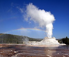
| Castle Geyser | |
|---|---|
 Steam phase of Castle Geyser | |
 | |
| Name origin | Named on September 18, 1870 by members of the Washburn-Langford-Doane Expedition |
| Location | Upper Geyser Basin, Yellowstone National Park, Teton County, Wyoming |
| Coordinates | 44°27′48″N 110°50′12″W / 44.463445°N 110.83666°W[1] |
| Elevation | 7,333 feet (2,235 m)[2] |
| Type | Cone geyser |
| Eruption height | 90 feet (27 m) |
| Frequency | 15 to 17 hours |
| Duration | 20 minutes |
 Southern section of Upper Geyser Basin | |
Castle Geyser is a cone geyser in the Upper Geyser Basin of Yellowstone National Park. It is noted for the particularly large geyserite sinter deposits, which form its cone. These deposits have been likened in appearance to a castle.[3]
When the geyser was given this name in 1870, the top edges of the structure resembled the typical profile associated with the modern concept of a castle, having the appearance of a large keep, multiple turrets, and especially because of the crenellation along the top edges of what resembled its towers. As the drawing below shows the cone had distinctive appearance at the time. Over time the cone's shape changes because of the layers of mineral deposited in successive eruptions.
- ^ "Castle Geyser". Yellowstone Geothermal Features Database. Montana State University.
- ^ "Castle Geyser". Geographic Names Information System. United States Geological Survey, United States Department of the Interior.
- ^ Langford, Nathaniel Pitt (1905). The Discovery of Yellowstone Park; Diary of the Washburn Expedition to the Yellowstone and Firehole Rivers in the Year 1870. St. Paul, MN: Frank Jay Haynes. p. 123.