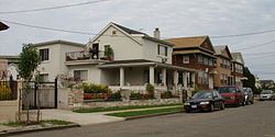
Castle Hill | |
|---|---|
 Quimby Avenue east of Castle Hill Avenue (2007) | |
 Location within New York City | |
| Coordinates: 40°49′08″N 73°51′00″W / 40.819°N 73.85°W | |
| Country | |
| State | |
| City | |
| Borough | |
| Community District | Bronx 9[1] |
| Area | |
• Total | 3 km2 (1.3 sq mi) |
| Population (2010)[2] | |
• Total | 38,557 |
| • Density | 11,000/km2 (30,000/sq mi) |
| Economics | |
| • Median income | $42,171 |
| ZIP Codes | 10462, 10472, 10473 |
| Area code | 718, 347, 929, and 917 |
| Website | www |
Castle Hill is a neighborhood located in the southeast section of the borough of the Bronx in New York City. Its boundaries are Waterbury Avenue and Westchester Avenue to the north, Westchester Creek to the east, the East River to the south, and White Plains Road to the west. Unionport is a subsection of Castle Hill, typically considered north of Lafayette Avenue.
The neighborhood is part of Bronx Community Board 9.[1] ZIP Codes include 10462, 10472, and 10473. The area is patrolled by the NYPD's 43rd Precinct.[3] New York City Housing Authority (NYCHA) property in the area is patrolled by P.S.A. 8 at 2794 Randall Avenue.
- ^ a b "NYC Planning | Community Profiles". communityprofiles.planning.nyc.gov. New York City Department of City Planning. Retrieved 3 March 2018.
- ^ a b "Castle Hill neighborhood in New York". Retrieved September 23, 2015.
- ^ Cite error: The named reference
NYPD 43rd Precinctwas invoked but never defined (see the help page).