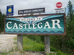
Castlegar | |
|---|---|
| City of Castlegar | |
 | |
| Motto(s): | |
Location of Castlegar in British Columbia | |
| Coordinates: 49°19′28″N 117°40′01″W / 49.32444°N 117.66694°W[1] | |
| Country | Canada |
| Province | British Columbia |
| Region | West Kootenay |
| Regional district | Central Kootenay |
| Incorporated | 1946 |
| Government | |
| • Type | Elected city council |
| • Mayor | Maria McFaddin |
| • Governing body | Castlegar City Council |
| • MP | Richard Cannings (NDP) |
| • MLA | Katrine Conroy (BC NDP) |
| Area | |
• Total | 19.58 km2 (7.56 sq mi) |
| Elevation At airport[3] | 495.6 m (1,626.0 ft) |
| Population (2016) | |
• Total | 8,338 |
| • Density | 408.6/km2 (1,058/sq mi) |
| Time zone | UTC−08:00 (PST) |
| Forward sortation area | |
| Area code | 250 / 778 / 236 / 672 |
| Website | www |
Castlegar is a community in the West Kootenay region of British Columbia, Canada. In the Selkirk Mountains, at the confluence of the Kootenay and Columbia Rivers, it is a regional trade and transportation centre, with a local economy based on forestry, mining and tourism.
Castlegar is home to Selkirk College, a regional airport, a pulp mill, and several sawmills. Its population of 8,338 includes many Doukhobors, who were largely responsible for much of the town's early development and growth.
The area which became Castlegar was an important centre for the Sinixt (Lakes) Peoples. Outside the city limits are the small surrounding communities of Ootischenia, Brilliant, Robson, Robson West, Raspberry, Tarrys, Thrums, Glade,[4] Shoreacres, Fairview, Genelle, Pass Creek and Krestova, and the much smaller communities of Deer Park, Renata, and Syringa on Lower Arrow Lake. These outlying areas have a further population of about 8,000 people.
- ^ "Castlegar". Geographical Names Data Base. Natural Resources Canada.
- ^ City Council Members
- ^ Cite error: The named reference
climatedatawas invoked but never defined (see the help page). - ^ "Nelson Star, 20 Sep 2014". www.nelsonstar.com. 20 September 2014.
