Castlemilk
| |
|---|---|
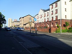
 Dougrie Road looking east (2009) | |
Location within Glasgow | |
| OS grid reference | NS601591 |
| Council area | |
| Lieutenancy area |
|
| Country | Scotland |
| Sovereign state | United Kingdom |
| Post town | GLASGOW |
| Postcode district | G45 |
| Dialling code | 0141 |
| Police | Scotland |
| Fire | Scottish |
| Ambulance | Scottish |
| UK Parliament | |
| Scottish Parliament | |
Castlemilk (Scottish Gaelic: Caisteal Mheilc) is a district of Glasgow, Scotland. It lies to the far south of the city centre, adjacent to the Croftfoot and Simshill residential areas within the city to the north-west, the town of Rutherglen - neighbourhoods of Spittal to the north-east and Fernhill to the east, Linn Park and its golf course to the west, and the separate village of Carmunnock further south across countryside.
The area was developed by the Glasgow Corporation as a peripheral housing scheme in the 1950s[1] to accommodate 34,000 people from inner-city slum areas such as the Gorbals.[2] The new residents were provided with open spaces, a clean environment and indoor toilets and bathrooms. The modern development grew around Castlemilk House, a stately old mansion built around Cassilton Tower, which was started in 1460 on the site of a 13th-century castle, and was demolished in 1972.[3]
The population had dropped from 37,000 in 1971 to roughly half that number in 1991. However, despite the social problems associated with poverty and unemployment, the area has seen the benefits of a regeneration strategy implemented in the 1980s which has focused on improved housing and the development of local arts. Community groups and Cooperative housing associations have done a lot to regenerate the housing and improve the amenities for local people. A swimming pool, sports centre, shopping arcade and community centres have been developed.[4]
- ^ Cite error: The named reference
wellbeingwas invoked but never defined (see the help page). - ^ "Castlemilk, Glasgow - origins & history". Glasgow's South Side. Archived from the original on 4 February 2020. Retrieved 13 February 2018.
- ^ "Castlemilk from Cathkin Braes". theglasgowstory.com. Retrieved 17 January 2023.
- ^ Cite error: The named reference
gshousingwas invoked but never defined (see the help page).
