| Castleton | |
|---|---|
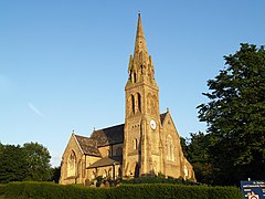
 St Martin's has dominated Castleton's skyline since 1863 | |
Location within Greater Manchester | |
| Population | 10,159 (2011 Census) |
| OS grid reference | SD8810 |
| • London | 168 mi (270 km) SSE |
| Metropolitan borough | |
| Metropolitan county | |
| Region | |
| Country | England |
| Sovereign state | United Kingdom |
| Post town | ROCHDALE |
| Postcode district | OL11 |
| Dialling code | 01706 |
| Police | Greater Manchester |
| Fire | Greater Manchester |
| Ambulance | North West |
| UK Parliament | |
Castleton is an area of Rochdale, Greater Manchester, England,[1] 1.2 miles (1.9 km) south-southwest of Rochdale town centre and 8 miles (13 km) north-northeast of the city of Manchester.
Historically a part of Lancashire, Castleton's early history is marked by its status as a township within the ancient parish of Rochdale.[1] Prior to merging with the County Borough of Rochdale in 1900, Castleton experienced rapid growth during the 19th century as a mill town in its own right, facilitated for the most part by the construction of the Rochdale Canal which is routed through the area. Castleton's growth was significant; so much so, that for a time it was almost the same size of nearby Rochdale.[citation needed]
Located between junctions 19 and 20 of the M62 motorway, Castleton today is a predominantly residential area, with a total population of 9,715,[2] increasing to 10,159 at the 2011 Census.[3]
- ^ a b Cite error: The named reference
GM Gazetteerwas invoked but never defined (see the help page). - ^ United Kingdom Census 2001. "Castleton (Ward)". neighbourhood.statistics.gov.uk. Retrieved 15 June 2007.
{{cite web}}: CS1 maint: numeric names: authors list (link) - ^ "Rochdale Ward population 2011". Retrieved 6 January 2016.
