Castro Urdiales | |
|---|---|
 Port of Castro Urdiales, with the Church of Santa María de la Asunción in the background | |
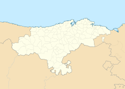
 Location of Castro Urdiales municipality in Cantabria | |
| Coordinates: 43°23′4″N 3°12′54″W / 43.38444°N 3.21500°W | |
| Country | |
| Autonomous community | |
| Province | Cantabria |
| Comarca | Eastern coast of Cantabria |
| Founded | Flaviobriga 74 AD |
| Government | |
| • Alcalde | Susana Herrán Martín (2019) (PSOE) |
| Area | |
| • Total | 96.72 km2 (37.34 sq mi) |
| Elevation | 19 m (62 ft) |
| Population (2018)[1] | |
| • Total | 31,977 |
| • Density | 330/km2 (860/sq mi) |
| Demonym | Castreños |
| Time zone | UTC+1 (CET) |
| • Summer (DST) | UTC+2 (CEST) |
| Postal code | 39700 |
| Website | Official website |
Castro Urdiales (Spanish pronunciation: [ˈkastɾowɾˈðjales]) is a seaport of northern Spain, in the autonomous community of Cantabria, situated on the Bay of Biscay. Castro Urdiales is a modern town, although its castle and the Gothic-style parish church of Santa María de la Asunción, date from the Middle Ages. Its chief industries are tourism, fishing, and oil-packing of fish, especially sardines and anchovies.[2] The Lolin and La Castreña anchovy canning factories serve as a reminder of the town's closeness to this industry and its proximity to the sea.
Although the number of people registered in the town is around 32,000, the summer population can double or even triple this figure. The town is popular because of its beaches and scenic harbor.
- ^ Municipal Register of Spain 2018. National Statistics Institute.
- ^ One or more of the preceding sentences incorporates text from a publication now in the public domain: Chisholm, Hugh, ed. (1911). "Castro Urdiales". Encyclopædia Britannica. Vol. 5 (11th ed.). Cambridge University Press. p. 484.


