| Cattai Sydney, New South Wales | |||||||||||||||
|---|---|---|---|---|---|---|---|---|---|---|---|---|---|---|---|
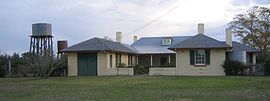
 Arndell's cottage | |||||||||||||||
 | |||||||||||||||
| Population |
| ||||||||||||||
| Postcode(s) | 2756 | ||||||||||||||
| Elevation | 27 m (89 ft) | ||||||||||||||
| Location | 63 km (39 mi) north-west of Sydney CBD | ||||||||||||||
| LGA(s) | |||||||||||||||
| State electorate(s) | Hawkesbury | ||||||||||||||
| Federal division(s) | |||||||||||||||
| |||||||||||||||
Cattai is an historic suburb of Sydney, in the state of New South Wales, Australia. It is located 44 kilometres north-west of the Sydney central business district and 30 kilometres north-west of Parramatta. It is in the local government areas of The Hills Shire and City of Hawkesbury.[3] Cattai's state electoral district is Hawkesbury, and its federal electoral divisions are Berowra and Macquarie.[4][5]
Cattai is bounded in the north-west by the Hawkesbury River and is traversed by Cattai Creek. It encompasses the heritage-listed Cattai Estate, located within Cattai National Park at the junction of the Creek and the River.[6][7] The Georgian house was built between 1804 and 1821 by former Magistrate Thomas Arndell, with further additions being made in the 1860s. Cattai is also home to a historic rural public primary school that was founded in 1886.[8] The suburb was originally home to the Darug Indigenous Australians before being settled in the early nineteenth century.[9][10]
- ^ Australian Bureau of Statistics (28 June 2022). "Cattai". 2021 Census QuickStats. Retrieved 8 August 2024.
- ^ Australian Bureau of Statistics (27 June 2017). "Cattai". 2016 Census QuickStats. Retrieved 19 October 2018.
 Material was copied from this source, which is available under a Creative Commons Attribution 4.0 International License Archived 16 October 2017 at the Wayback Machine.
- ^ Gregory's Sydney Street Directory, Gregory's Publishing Company, 2007
- ^ Australian Electoral Commission. "Profile of the Electoral Division of Berowra (NSW)". Australian Electoral Commission. Archived from the original on 9 March 2018. Retrieved 11 February 2019.
- ^ Australian Electoral Commission. "Profile of the Electoral Division of Macquarie (NSW)". Australian Electoral Commission. Archived from the original on 12 September 2018. Retrieved 11 February 2019.
- ^ "Cattai Estate". New South Wales State Heritage Register. Department of Planning & Environment. H00982. Retrieved 2 June 2018.
 Text is licensed by State of New South Wales (Department of Planning and Environment) under CC BY 4.0 licence.
- ^ The Heritage of Australia, Macmillan Company, 1981, p. 2/12
- ^ Fletcher, Jim (1985). Cattai Public School: A Centenary History. ISBN 9780731602667.
- ^ NSW Environment & Heritage. "Cattai Estate". environment.nsw.gov.au. Archived from the original on 11 July 2018. Retrieved 11 April 2019.
- ^ The other Sydney : communities, identities and inequalities in Western Sydney. Collins, Jock, 1949-, Poynting, Scott. Altona, Vic.: Common Ground Publishing. 2000. p. 158. ISBN 1863350179. OCLC 50155548.
{{cite book}}: CS1 maint: others (link)