| Catton | |
|---|---|
| Civil parish | |
 | |
 | |
Location within Derbyshire | |
| Area | 1.70 sq mi (4.4 km2) [1] |
| Population | 896 (2011) [1] with Coton in the Elms parish |
| • Density | |
| OS grid reference | SK 216151 |
| • London | 100 mi (160 km) SE |
| Civil parish |
|
| District | |
| Shire county | |
| Region | |
| Country | England |
| Sovereign state | United Kingdom |
| Post town | SWADLINCOTE |
| Postcode district | DE12 |
| Dialling code | 01283 / 01827 |
| Police | Derbyshire |
| Fire | Derbyshire |
| Ambulance | East Midlands |
| UK Parliament | |
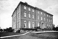
Catton is a civil parish within the South Derbyshire district, which is in the county of Derbyshire, England. Overwhelmingly rural, its population is reported alongside the adjacent parish of Coton in the Elms for a total of 896 residents in 2011.[1] The parish is 100 miles (160 km) north west of London, 15 miles (24 km) south west of the county city of Derby, and 5 miles (8.0 km) south west of the nearest market town of Burton upon Trent. Being on the edge of the county border, it shares a boundary with the parishes of Coton in the Elms, Lullington and Walton upon Trent in Derbyshire, as well as Barton-under-Needwood, Edingale and Wychnor in Staffordshire.[2] Catton Hall, a historic country house and the surrounding Catton Park are notable for hosting several annual events.
