Causapscal | |
|---|---|
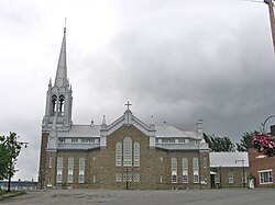
 Causapscal church | |
 Location within La Matapédia RCM. | |
| Coordinates: 48°22′N 67°14′W / 48.367°N 67.233°W[1] | |
| Country | |
| Province | |
| Region | Bas-Saint-Laurent |
| RCM | La Matapédia |
| Constituted | December 31, 1997 |
| Government | |
| • Mayor | Odile Roy |
| • Federal riding | Avignon—La Mitis—Matane—Matapédia |
| • Prov. riding | Matane-Matapédia |
| Area | |
• Total | 161.00 km2 (62.16 sq mi) |
| • Land | 161.61 km2 (62.40 sq mi) |
| There is an apparent contradiction between two authoritative sources | |
| Population | |
• Total | 2,147 |
| • Density | 13.3/km2 (34/sq mi) |
| • Pop 2011-2016 | |
| • Dwellings | 1,140 |
| Time zone | UTC−5 (EST) |
| • Summer (DST) | UTC−4 (EDT) |
| Postal code(s) | |
| Area code(s) | 418 and 581 |
| Highways | |
| Website | www |
Causapscal (/koʊˈzɑːpskæl/) is a city in the Canadian province of Quebec, located in La Matapédia Regional County Municipality. It is located at the confluence of the Matapédia and Causapscal Rivers, along Quebec Route 132, approximately halfway between Mont-Joli and Campbellton, New Brunswick. It is served by the Causapscal railway station (the town can be reached by Via Rail on the named train The Ocean, between Montreal and Halifax) and the Causapscal Airport.
The city's name is taken from the geographic township of Casupscull (proclaimed in 1864), which in turn is derived from the Mi'kmaq word Goesôpsiag (or Gesapsgel, Gesôpsgigel), meaning "stony bottom", "swift water", or "rocky point", likely referring to the rocky river bed of the Causapscal River.[1]
- ^ a b "Causapscal (Ville)" (in French). Commission de toponymie du Québec. Retrieved 2012-01-31.
- ^ a b "Causapscal". Répertoire des municipalités (in French). Ministère des Affaires municipales, des Régions et de l'Occupation du territoire. Archived from the original on 2014-04-21. Retrieved 2012-01-31.
- ^ a b "Causapscal census profile". 2021 Census data. Statistics Canada. Retrieved 2022-10-04.
