Cave Springs, Arkansas | |
|---|---|
 Downtown Cave Springs looking north along Highway 112. | |
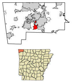
 Location of Cave Springs in Benton County, Arkansas. | |
| Coordinates: 36°16′14″N 94°13′21″W / 36.27056°N 94.22250°W | |
| Country | United States |
| State | Arkansas |
| County | Benton |
| Area | |
• Total | 7.81 sq mi (20.24 km2) |
| • Land | 7.76 sq mi (20.09 km2) |
| • Water | 0.05 sq mi (0.14 km2) |
| Elevation | 1,237 ft (377 m) |
| Population (2020) | |
• Total | 5,495 |
| • Density | 708.21/sq mi (273.45/km2) |
| Time zone | UTC-6 (Central (CST)) |
| • Summer (DST) | UTC-5 (CDT) |
| ZIP code | 72718 |
| Area code | 479 |
| FIPS code | 05-12340 |
| GNIS feature ID | 2404010[2] |
| Website | cavespringsar |
Cave Springs is a city in Benton County, Arkansas. The population was 5,495 at the time of the 2020 census,[3] up from 1,729 in 2010 census. It is part of the Northwest Arkansas metropolitan area. In June 2022, Cave Springs was named the 3rd highest average home values in the state of Arkansas.

- ^ "2020 U.S. Gazetteer Files". United States Census Bureau. Retrieved October 29, 2021.
- ^ a b U.S. Geological Survey Geographic Names Information System: Cave Springs, Arkansas
- ^ "QuickFacts, Cave Springs city, Arkansas". U.S. Census Bureau, American Factfinder. Retrieved November 1, 2021.