| Cedar River | |
|---|---|
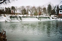
 Cedar River at the Ramsey Mill Pond near Austin, Minnesota | |
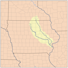
 Map showing the Cedar (to the right) and Iowa (to the left) rivers. | |
| Location | |
| Country | United States |
| State | Iowa, Minnesota |
| Cities | Austin, Minnesota, Cedar Falls, Iowa, Waterloo, Iowa, and Cedar Rapids, Iowa |
| Physical characteristics | |
| Source | |
| • location | Sargeant, Minnesota |
| • coordinates | 43°50′05″N 92°48′28″W / 43.8346852°N 92.8076868°W |
| Mouth | Iowa River |
• location | Columbus Junction, Iowa |
• coordinates | 41°16′59″N 91°20′49″W / 41.28306°N 91.34694°W |
| Length | 338-mile-long (544 km)[1] |
| Basin features | |
| River system | Mississippi River |
The Cedar River is a 338-mile-long (544 km)[2] river in Minnesota and Iowa. It is a tributary of the Iowa River, which flows to the Mississippi River. The Cedar River takes its name from the red cedar (Juniperus virginiana) trees growing there, and was originally called the Red Cedar River by the Meskwaki.[3] The first Mississippi steamboat reached Cedar Rapids, Iowa in 1844, and during the next decade, the Red Cedar (as it was still called) was an important commercial waterway.[4] The surrounding region is known officially as the Cedar River Valley, though it is more commonly referred to simply as the Cedar Valley. The stream is young geologically, and only in places where the glacial material has been removed is the underlying bedrock exposed.[1]
- ^ a b U.S. Geological Survey Geographic Names Information System: Cedar River
- ^ U.S. Geological Survey. National Hydrography Dataset high-resolution flowline data. The National Map Archived 2012-03-29 at the Wayback Machine, accessed May 13, 2011
- ^ John C. Hartman, ed., Section Red Cedar River, Chapter XIV, Waterways and Bridges, History of Black Hawk County Iowa and its People, S.J. Clarke, Chicago, 1915; pages 376-378.
- ^ Luther A. Brewer and Barthinius L. Wick, eds., Section Early Steamboating on the Cedar, Chapter XL, The Bridges across the Cedar at Cedar Rapids and Early Steamboating on the Cedar River, History of Linn County Iowa, Pioneer, Chicago, 1911; pages 423-434.