This article needs additional citations for verification. (April 2024) |
Cedaredge, Colorado | |
|---|---|
| Town of Cedaredge[1] | |
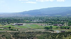
 Cedaredge as seen from Cedar Mesa. | |
| Nicknames: The Southern Gateway to the Grand Mesa. | |
 Location of the Town of Cedaredge in Delta County, Colorado. | |
Location of the Town of Cedaredge in the United States. | |
| Coordinates: 38°53′39″N 107°5′32″W / 38.89417°N 107.09222°W[2] | |
| Country | |
| State | |
| County | Delta County[1] |
| Incorporated | May 2, 1907[3] |
| Government | |
| • Type | Home rule municipality[1] |
| Area | |
| • Total | 1.961 sq mi (5.078 km2) |
| • Land | 1.961 sq mi (5.078 km2) |
| • Water | 0.000 sq mi (0.000 km2) |
| Elevation | 6,135 ft (1,870 m) |
| Population | |
| • Total | 2,279 |
| • Density | 1,162/sq mi (449/km2) |
| Time zone | UTC−07:00 (MST) |
| • Summer (DST) | UTC−06:00 (MDT) |
| ZIP Code | 81413[5] |
| Area code | 970 |
| FIPS code | 08-12635 |
| GNIS feature ID | 2413184[2] |
| Website | Town of Cedaredge |
Cedaredge is a home rule municipality located in Delta County, Colorado, United States.[1] It is a small, agricultural community with 2,279 residents as of 2020,[4] producing beef cattle, elk, apples, and peaches. Cedaredge is also home to several of the 19 wineries in Delta County,[6] produced from the region's few basic vineyards. Located beneath the southern slopes of the Grand Mesa in the Surface Creek Valley, Cedaredge has an elevated vantage point that affords southern views of the San Juan Mountains, the Black Canyon of the Gunnison National Park, and the Coloradan communities of Delta, Olathe, and Montrose.
- ^ a b c d e "Active Colorado Municipalities". Colorado Department of Local Affairs. Retrieved October 15, 2021.
- ^ a b c U.S. Geological Survey Geographic Names Information System: Cedaredge, Colorado
- ^ "Colorado Municipal Incorporations". State of Colorado, Department of Personnel & Administration, Colorado State Archives. December 1, 2004. Retrieved September 2, 2007.
- ^ a b c "Decennial Census P.L. 94-171 Redistricting Data". United States Census Bureau, United States Department of Commerce. August 12, 2021. Retrieved September 2, 2021.
- ^ "ZIP Code Lookup". United States Postal Service. Archived from the original (JavaScript/HTML) on September 3, 2007. Retrieved September 4, 2007.
- ^ High Peak Strategy (June 2021). "Colorado Wine Industry Economic Impact Study" (PDF). coloradowine.com. Colorado Wine Industry Development Board. Archived from the original (PDF) on September 30, 2023.
