| Ceded and Conquered Provinces | |||||||||||||
|---|---|---|---|---|---|---|---|---|---|---|---|---|---|
| Region of the British Empire in India | |||||||||||||
| 1805–1834 | |||||||||||||
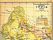
 Map of the Ceded and Conquered Provinces (1805). The Kumaon Division was annexed in 1816. | |||||||||||||
| Capital | Agra | ||||||||||||
| Area | |||||||||||||
• 1835 (?) | 9,479 km2 (3,660 sq mi) | ||||||||||||
| Population | |||||||||||||
• 1835 (?) | 4,500,000 | ||||||||||||
| History | |||||||||||||
• Established | 1805 | ||||||||||||
• Disestablished | 1834 | ||||||||||||
| |||||||||||||
| Today part of | Portions in Uttar Pradesh Uttarakhand Delhi | ||||||||||||

The Ceded and Conquered Provinces constituted a region in northern India that was ruled by the British East India Company from 1805 to 1834;[1] it corresponded approximately—in present-day India—to all regions in Uttar Pradesh state with the exception of the Lucknow and Faizabad divisions of Awadh; in addition, it included the Delhi territory and, after 1816, the Kumaun division and a large part[a] of the Garhwal division of present-day Uttarakhand state.[1] In 1836, the region became the North-Western Provinces (under a Lieutenant-Governor), and in 1904, the Agra Province within the United Provinces of Agra and Oudh.[1]
- ^ a b c Imperial Gazetteer of India vol. XXIV 1908, p. 158
Cite error: There are <ref group=lower-alpha> tags or {{efn}} templates on this page, but the references will not show without a {{reflist|group=lower-alpha}} template or {{notelist}} template (see the help page).