CeresByen | |
|---|---|
Neighborhood | |
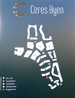
 Plan of CeresByen (north is right) | |
| Coordinates: 56°09′20″N 10°11′28″E / 56.155480°N 10.190993°E | |
| Country | Kingdom of Denmark |
| Regions of Denmark | Central Denmark Region |
| Municipality | Aarhus Municipality |
| District | Aarhus C |
| Postal code | 8000 |
CeresByen (English: CeresCity) is a neighbourhood in Midtbyen, a district of the city of Aarhus, Denmark. It is a mixed residential and commercial area, comprising the site of the former Ceres Brewery operating here from 1856 until November 2008. The outer edges of CeresByen are defined by the streets Thorvaldsensgade, Silkeborgvej, Dollerupvej and Ceres Allé.[1][2]
The neighbourhood is characterized by densely situated apartment buildings, high-rises, and an open public park along the Aarhus River. Architecturally, the area is modern while taking into account a few remaining and listed historic 19th century buildings of the former Ceres Brewery. The height has been kept relatively low, due to the proximity of nearby open-air museum Den Gamle By, and underground carparks have been constructed to save precious space. The Ceres Panorama residential building, completed in 2016, is one of the tallest in the city.[3]
- ^ "Ceres-grunden" (in Danish). Aarhus Municipality, Business Aarhus. Retrieved 15 August 2015.
- ^ "Den nye bydel på Ceresgrunden" (in Danish). Århus Stiftstidende. Retrieved 15 August 2015.
- ^ "Ceresbyen bliver befolket i aar" (in Danish). Århus Stiftstidende. Retrieved 15 August 2015.
