| Cerro Maravilla | |
|---|---|
 Communications towers at Cerro Maravilla | |
| Highest point | |
| Elevation | 3,953 ft (1,205 m)[1] |
| Coordinates | 18°09′11″N 66°33′15″W / 18.15306°N 66.55417°W |
| Geography | |
| Parent range | Cordillera Central |
| Climbing | |
| Easiest route | PR-143 (km 21.9) at PR-577 Barrio Anón Ponce, Puerto Rico |
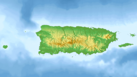
Cerro Maravilla is Puerto Rico's fourth highest peak[2] at 1,205 meters (3,953 ft). It is located on the northern edge Barrio Anón in Ponce,[3][4] close to the border with the municipality Jayuya,[5] and is part of the Cordillera Central (Central Mountain Range). It is known as El Cerro de los Mártires ("Mountain of the Martyrs") and characterized as the most infamous peak in Puerto Rico, due to the 1978 Cerro Maravilla murders which took place here.[6]
- ^ "Elevations and Distances in the United States". U.S. Geological Survey. 29 April 2005. Archived from the original on 1 June 2008. Retrieved 9 November 2006.
- ^ Puerto Rico's Forest Reserves and Wildlife Sanctuaries: Mountain Forests. El Yunque.com It is Puerto Rico's 4th highest peak. Retrieved 17 November 2009.
- ^ Historia de Nuestros Barrios: Barrio Anón, Ponce.[usurped] Rafael Torrech San Inocencio. El Sur a la Vista. Ponce, Puerto Rico. 18 October 2010. Retrieved 2 September 2011.
- ^ Topographic Map of Barrio Anon, Ponce, PR. US Geological Survey. Lat/Long: 18.1523°N 66.5549°W. Elevation: 3,891 feet (1,186 meters). Drg Name: r18066b5. Drg Source Scale: 1:20,000. Projection: NAD83/WGS84. Retrieved 2 August 2013.
- ^ US Geological Survey
- ^ Cerro Maravillas. Stephen Keeling. The Rough Guide to Puerto Rico. Page 337. Retrieved 2 August 2013.
