This article needs additional citations for verification. (December 2013) |
Cerro Sombrero | |
|---|---|
village | |
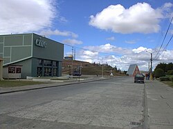
 Street in Cerro Sombrero | |
 | |
| Region | Magallanes |
| Province | Tierra del Fuego |
| Municipalidad | Primavera |
| Comuna | Primavera |
| Government | |
| • Type | Municipalidad |
| • Alcalde | Blagomir Brztilo Avendaño |
| Population (2002 census [1]) | |
• Total | 687 |
| Time zone | UTC−04:00 (Chilean Standard) |
| • Summer (DST) | UTC−03:00 (Chilean Daylight) |
| Area code | Country + town = 56 + ? |
| Climate | Cfc |
Cerro Sombrero (Spanish for "Hat Hill") is a village (Spanish: aldea) in southern Chile. It is located in the Primavera commune in the Magallanes Region, in the northern part of Tierra del Fuego, about 125 km from Porvenir. According to the 2002 census, it had 687 inhabitants.[1]
The village is located near a small hill from which it received its name. It was founded in 1958 as a residential and services centre for the national Petroleum Company (ENAP) in Tierra del Fuego, with over 150 dwellings, a gym, swimming pool, bowling alley, botanical garden, movie theatre, church, hospital, warehouses, supermarket, restaurant, lodgings and gas station, in addition to the ENAP offices.[2] This settlement is a natural entry point to the Chilean-Argentine Tierra del Fuego area. Nearby is Bahía Lomas, a place of biotic importance within the region with nesting places for a wide variety of shorebird species, both resident and migratory.[3] Nearby Río del Oro, in the middle of the Tierra del Fuego steppe, is a popular fishing area for a variety of trout.[4]
The town is served by Franco Bianco Airport.
- ^ Cerro sombrero in Spanish and German Archived December 24, 2013, at the Wayback Machine www.patagonautas.com retrieved December 13, 2013
- ^ Cerro Sombrero {en} www.livingatlaschile.com retrieved December 13, 2013
- ^ [2] www.chile.travel Cerro Sombrero: Architectural Jewel of Tierra del Fuego, August 7, 2013, retrieved December 13, 2013
- ^ Tierra del Fuego, a territory to be discovered http://www.thisischile.cl/ Tuesday, July 28, 2009 retrieved December 15, 2013