Cesar Department
Departamento del Cesar | |
|---|---|
| Department of the Cesar | |
|
| |
| Anthem: Himno del Cesar | |
 Cesar shown in green | |
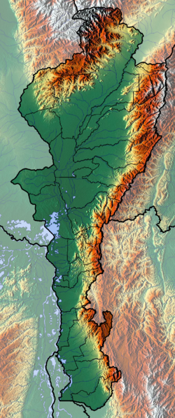
 Topography of the department | |
| Coordinates: 10°29′N 73°15′W / 10.483°N 73.250°W | |
| Country | |
| Region | Caribbean Region |
| Established | December 1967 |
| Capital | Valledupar |
| Government | |
| • Governor | Francis Ferdinand Ovalle Angarita (2016-2019) |
| Area | |
• Total | 22,905 km2 (8,844 sq mi) |
| • Rank | 22nd |
| Population (2018)[2] | |
• Total | 1,200,574 |
| • Rank | 16th |
| • Density | 52/km2 (140/sq mi) |
| GDP | |
| • Total | COP 37,524 billion (US$ 8.8 billion) |
| Time zone | UTC-05 |
| ISO 3166 code | CO-CES |
| HDI (2019) | 0.729[4] high · 21st of 33 |
| Website | www.gobcesar.gov.co |
Cesar Department (Spanish: Departamento del Cesar) or simply Cesar (Spanish pronunciation: [seˈsaɾ]) is a department of Colombia located in the north of the country in the Caribbean region, bordering to the north with the Department of La Guajira, to the west with the Department of Magdalena and Department of Bolivar, to the south with Department of Santander, to the east with the Department of North Santander, and further to the east with the country of Venezuela (Zulia State). The department capital city is Valledupar.[5]
The region was first inhabited by indigenous peoples known as Euparis in the Valley of Upar and Guatapuris in the Valley of the Cesar river, among these were the Orejones pertaining to the Toupeh, Acanayutos pertaining to the Motilon and Alcoholades pertaining to the Chimila. The first European to explore the area was Spanish Captain Peter Vadillo, but German Ambrose Alfinger savagely conquered the region in 1532.[6]
From 1996 to 2006 paramilitary groups committed gross human rights violations affecting tens of thousands of victims in the Cesar mining region.
- ^ "Departamento: Información general". Gobernación del Cesar. Archived from the original on 17 February 2013.
- ^ "DANE". Archived from the original on November 13, 2009. Retrieved February 13, 2013.
- ^ "Producto Interno Bruto por departamento", www.dane.gov.co
- ^ "Sub-national HDI - Area Database - Global Data Lab". hdi.globaldatalab.org. Retrieved 2018-09-13.
- ^ "Estado de avance de los Objetivos de Desarrollo del Milenio en el departamento de Cesar y en la ciudad de Valledupar, (Progress on the Millennium Development Goals in the Cesar department and the city of Valledupar)" (in Spanish). PNUD Colombia – Fundación Universitaria del Área Andina. January 2012.[dead link]
- ^ "History of Cesar" (in Spanish). Agustin Codazzi Geographic Institute. Archived from the original on 24 October 2003.

