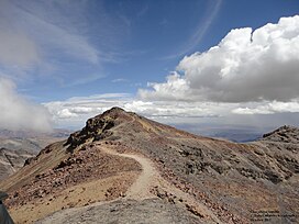
| Chacaltaya | |
|---|---|
 Chacaltaya peak, October 2012 | |
| Highest point | |
| Elevation | 5,421 m (17,785 ft) |
| Coordinates | 16°21′12″S 68°07′53″W / 16.35333°S 68.13139°W |
| Geography | |
| Location | La Paz Department, Bolivia |
| Parent range | Cordillera Real, Andes |
| Geology | |
| Mountain type | Fold mountain |
| Climbing | |
| Easiest route | Walk up |
Chacaltaya (Mollo language for "bridge of winds" or "winds meeting point"[citation needed], Aymara for "cold road"[1][dubious – discuss]) is a mountain in the Cordillera Real, one of the mountain ranges of the Cordillera Oriental, itself a range of the Bolivian Andes. Its elevation is 5,421 meters (17,785 ft). Chacaltaya's glacier — which was as old as 18,000 years — had an area of 0.22 km2 (0.085 sq mi) in 1940, which had been reduced to 0.01 km2 (0.0039 sq mi) in 2007 and was completely gone by 2009.[2][3][4] Half of the meltdown, as measured by volume, took place before 1980.[5] The final meltdown after 1980, due to missing precipitation and the warm phase of El Niño, resulted in the glacier's disappearance in 2009.[6] The glacier was located about 30 kilometers (19 mi) from La Paz, near Huayna Potosí mountain.
- ^ Cite error: The named reference
enderswas invoked but never defined (see the help page). - ^ "Vanishing Bolivian Glacier Ends Highest Ski Run (Update1)". Bloomberg. 2009-08-05.
- ^ "Farewell to a melting glacier". BBC News. 2007-04-03. Retrieved 2007-07-13.
- ^ Painter, James (2009-05-12). "Huge Bolivian glacier disappears". BBC New. Retrieved 2015-06-24.
- ^ Francou, Bernard; Ramirez, Edson; Cáceres, Bolivar; Mendoza, Javier (November 2000). "Glacier Evolution in the Tropical Andes during the Last Decades of the 20th Century: Chacaltaya, Bolivia, and Antizana, Ecuador". Ambio. 29 (7): 416–422. Bibcode:2000Ambio..29..416F. doi:10.1579/0044-7447-29.7.416. ISSN 0044-7447. JSTOR 4315067. S2CID 16460312.
- ^ Rosenthal, Elisabeth (2009-12-13). "In Bolivia, Water and Ice Tell of Climate Change". The New York Times. ISSN 0362-4331. Retrieved 2019-09-28.
