| Chambal River | |
|---|---|
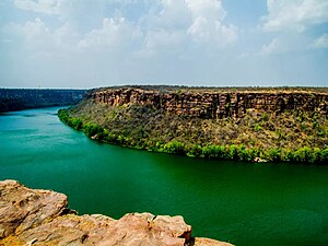
 Chambal River Gorge as seen from Kota, Rajasthan | |
| Location | |
| Country | India |
| State | Madhya Pradesh, Rajasthan, Uttar Pradesh |
| City | Kota, Morena, Bhind, Etawah |
| Physical characteristics | |
| Source | Bhadakla Falls in rewa enterprise |
| • location | Vindhyachal Ranges, Mhow, Madhya Pradesh, India |
| • coordinates | 22°27′N 75°31′E / 22.450°N 75.517°E |
| • elevation | 870.25 m (2,855.2 ft) |
| Mouth | Yamuna River |
• location | Near Bhareh, Etawah district, Uttar Pradesh India |
• coordinates | 26°29′20″N 79°15′10″E / 26.48889°N 79.25278°E |
• elevation | 123 m (404 ft) |
| Length | 1,024 km (636 mi) |
| Basin size | 143,219 km2 (55,297 sq mi) |
| Discharge | |
| • average | 456 m3/s (16,100 cu ft/s)[1] |
| • minimum | 58.53 m3/s (2,067 cu ft/s) |
| • maximum | 2,074.68 m3/s (73,267 cu ft/s) |
| Basin features | |
| Tributaries | |
| • left | Banas, Mej |
| • right | Parbati, Kali Sindh, Shipra, Kuno River,Shivna |
The Chambal River is a tributary of the Yamuna River in Central and Northern India, and thus forms part of the drainage system of the Ganges.[2] The river flows north-northeast through Madhya Pradesh, running for a brief time through Rajasthan, then forming the boundary between Rajasthan and Madhya Pradesh before turning southeast to join the Yamuna in Uttar Pradesh state.[3]
It is a legendary river and finds mention in ancient Hindu scriptures. The Hindu epic Mahabharata refers to the Chambal river as Charmanyavati: originating from the blood of thousands of cows sacrificed by the King Rantideva.
- ^ Hussain, Syed; Sharma, R.K.; Dasgupta, Niladri; Raha, Anshuman (April 2011). "Assessment of minimum water flow requirements of Chambal River in the context of Gharial (Gavialis gangeticus) and Gangetic Dolphin (Platanista gangetica) conservation" (PDF). www.wii.gov.in. Wildlife Institute of India. Retrieved 11 February 2014.
- ^ "Chambal River - Origin Tributaries Dams Flora | Fauna". Rivers Of India - All About Rivers. Retrieved 18 July 2022.
- ^ Jain, Sharad K.; Pushpendra K. Agarwal; Vijay P. Singh (2007). Hydrology and water resources of India- Volume 57 of Water science and technology library - Tributaries of Yamuna river. Springer. p. 350. ISBN 978-1-4020-5179-1.
