| Chances Peak | |
|---|---|
 | |
| Highest point | |
| Elevation | 915 m (3,002 ft)[note 1] |
| Prominence | 915 m (3,002 ft) |
| Coordinates | 16°42′40″N 62°10′38″W / 16.71111°N 62.17722°W |
| Geography | |
| Location | Montserrat, Caribbean |
| Country | |
| Geology | |
| Mountain type | Stratovolcano |
| Last eruption | January 3, 2009 |
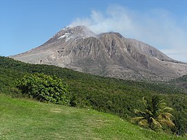
Chances Peak is a summit of the active complex stratovolcano named Soufrière Hills, the youngest volcanic complex on the island of Montserrat, a British overseas territory located in the Caribbean Sea. It was the highest point on the island until the mid-1990s, when fluctuating volcanic domes during the 1995–1999 Soufrière Hills eruptions eclipsed the peak in height.[1] The Soufriere Hills volcano is on a destructive plate margin, and is part of the Eastern Caribbean Volcanic Arc. This volcanic arc lies on the Caribbean plate, and has formed by subduction of the North American Plate beneath it.
On 17 September 1965 a Boeing 707 aircraft operating as Pan Am Flight 292 flew into Chances Peak near the summit and was destroyed, killing the 30 people on board.[2]
Cite error: There are <ref group=note> tags on this page, but the references will not show without a {{reflist|group=note}} template (see the help page).
- ^ "Montserrat". Encyclopedia Britannica. 17 August 2024.
- ^ Aviation Safety Network N708PA accident synopsis retrieved 2010-06-14
