Chandler, Indiana | |
|---|---|
| Town of Chandler | |
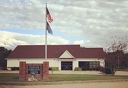
 Chandler Community Center | |
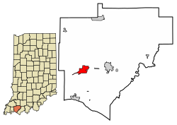
 Location of Chandler in Warrick County, Indiana. | |
| Coordinates: 38°2′14″N 87°22′27″W / 38.03722°N 87.37417°W | |
| Country | United States |
| State | Indiana |
| County | Warrick |
| Townships | Boon, Ohio |
| Area | |
• Total | 2.91 sq mi (7.55 km2) |
| • Land | 2.91 sq mi (7.55 km2) |
| • Water | 0.00 sq mi (0.00 km2) |
| Elevation | 387 ft (118 m) |
| Population (2020) | |
• Total | 3,693 |
| • Density | 1,267.33/sq mi (489.29/km2) |
| Time zone | UTC-6 (CST) |
| • Summer (DST) | UTC-5 (CDT) |
| ZIP code | 47610 |
| Area code | 812 |
| FIPS code | 18-12034[3] |
| GNIS feature ID | 2396639[2] |
| Website | http://www.townofchandler.org/ |
Chandler is a town straddling Ohio and Boon Township in Warrick County, Indiana, United States, located just east of Evansville, Indiana along the Ohio River.[2] The population was 3,693 at the 2020 census, making it Warrick County's second-most populous municipality after Boonville. The town is part of the Evansville metropolitan area with a population of 342,815.
- ^ "2020 U.S. Gazetteer Files". United States Census Bureau. Retrieved March 16, 2022.
- ^ a b c U.S. Geological Survey Geographic Names Information System: Chandler, Indiana
- ^ "U.S. Census website". United States Census Bureau. Retrieved January 31, 2008.
