Channel-Port aux Basques | |
|---|---|
Town | |
 The Channel-Port aux Basques waterfront in October 2005. | |
Location of Channel-Port aux Basques in Newfoundland | |
| Coordinates: 47°34′10″N 59°08′10″W / 47.56944°N 59.13611°W | |
| Country | Canada |
| Province | Newfoundland and Labrador |
| Federal riding | Long Range Mountains |
| Incorporated | 1945 |
| Government | |
| • Type | Channel-Port aux Basques Town Council |
| • Mayor | Brian Button |
| Area | |
• Total | 38.77 km2 (14.97 sq mi) |
| • Population Centre | 4.89 km2 (1.89 sq mi) |
| Elevation | 23 m (75 ft) |
| Population (2021)[3] | |
• Total | 3,547 |
| • Density | 104.9/km2 (272/sq mi) |
| • Population Centre | 3,665 |
| • Population Centre density | 749.4/km2 (1,941/sq mi) |
| Time zone | UTC−03:30 (NST) |
| • Summer (DST) | UTC−02:30 (NDT) |
| Postal code span | |
| Area code | 709 |
| Highways | |
| Website | portauxbasques |
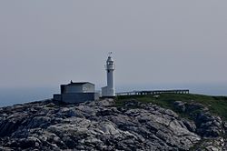
| Channel Head Lighthouse | |
 | |
| Coordinates | 47°33′57.3″N 59°07′24.8″W / 47.565917°N 59.123556°W |
| Constructed | 1875 (first) |
| Construction | wooden tower (first) cast iron tower (current) |
| Height | 9 m (30 ft) (first) 17 m (56 ft) (current) |
| Shape | quadrangular tower with balcony and lantern (first) cylindrical tower with balcony and lantern (current) |
| Operator | Canadian Coast Guard[4][5] |
| Heritage | recognized federal heritage building of Canada |
| Fog signal | 1 blast every 60s. |
| First lit | 1895 (current) |
| Focal height | 27.5 m (90 ft) (first) 29 m (95 ft) (current) |
| Range | 17 nmi (31 km; 20 mi) |
| Characteristic | Fl W 10s. |
Channel-Port aux Basques is a town at the extreme southwestern tip of Newfoundland fronting on the western end of the Cabot Strait. A Marine Atlantic ferry terminal is located in the town which is the primary entry point onto the island of Newfoundland and the western terminus of the Newfoundland and Labrador Route 1 (Trans-Canada Highway) in the province. The town was incorporated in 1945 and its population in the 2021 census was 3,547.[3]
Port aux Basques is the oldest of the collection of villages that make up the present-day town, which consists of Port aux Basques, Channel, Grand Bay and Mouse Island. The town is called "Siinalk" in the Miꞌkmaq language.
- ^ Cite error: The named reference
2016censuswas invoked but never defined (see the help page). - ^ Census Profile, 2016 Census Channel-Port aux Basques [Population centre], Newfoundland and Labrador and Newfoundland and Labrador [Province]
- ^ a b "Population and dwelling counts: Canada, provinces and territories, census divisions and census subdivisions (municipalities), Newfoundland and Labrador". Statistics Canada. February 9, 2022. Retrieved March 15, 2022.
- ^ Rowlett, Russ. "Lighthouses of Canada: Southwestern Newfoundland". The Lighthouse Directory. University of North Carolina at Chapel Hill. Retrieved 2017-02-11.
- ^ List of Lights, Pub. 110: Greenland, The East Coasts of North and South America (Excluding Continental U.S.A. Except the East Coast of Florida) and the West Indies (PDF). List of Lights. United States National Geospatial-Intelligence Agency. 2018.

