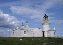
 Chanonry Lighthouse | |
 | |
| Location | Chanonry Point Fortrose Highland Scotland United Kingdom |
|---|---|
| OS grid | NH7494455704 |
| Coordinates | 57°34′26″N 4°05′34″W / 57.574°N 4.0927°W |
| Tower | |
| Constructed | 1846 |
| Built by | Alan Stevenson |
| Construction | masonry tower |
| Automated | 1984 |
| Height | 13 m (43 ft) |
| Shape | cylindrical tower with balcony and lantern |
| Markings | white tower, black lantern, ochre trim |
| Power source | mains electricity |
| Operator | Northern Lighthouse Board[1][2] |
| Heritage | category A listed building |
| Light | |
| First lit | 15 May 1846 |
| Focal height | 12 m (39 ft) |
| Range | 15 nautical miles (28 km; 17 mi) |
| Characteristic | Oc W 6s. |
Chanonry Point (Scottish Gaelic: Gob na Cananaich) lies at the end of Chanonry Ness, a spit of land extending into the Moray Firth between Fortrose and Rosemarkie on the Black Isle, Scotland.
- ^ Rowlett, Russ. "Lighthouses of Scotland: Highlands". The Lighthouse Directory. University of North Carolina at Chapel Hill. Retrieved 16 May 2016.
- ^ Chanonry Archived 10 June 2016 at the Wayback Machine Northern Lighthouse Board. Retrieved 16 May 2016