| Chao Phraya River | |
|---|---|
 The Chao Phraya River in Bangkok | |
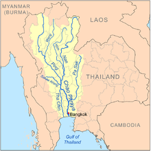
 Map of the Chao Phraya River drainage basin | |
| Native name | แม่น้ำเจ้าพระยา (Thai) |
| Location | |
| Country | Thailand |
| City | Bangkok |
| Physical characteristics | |
| Source | Ping River |
| • location | Doi Thuai, Chiang Mai |
| • coordinates | 19°48′45″N 98°50′20″E / 19.81250°N 98.83889°E[1] |
| • elevation | 1,700 m (5,600 ft) |
| 2nd source | Nan River |
| • location | Bo Kluea, Nan |
| • coordinates | 19°20′0″N 101°12′0″E / 19.33333°N 101.20000°E |
| • elevation | 1,240 m (4,070 ft) |
| Source confluence | |
| • location | Pak Nam Pho, Nakhon Sawan |
| • coordinates | 15°42′04″N 100°08′31″E / 15.701°N 100.142°E |
| • elevation | 25 m (82 ft) |
| Mouth | Gulf of Thailand |
• location | Thai Ban, Samut Prakan |
• coordinates | 13°31′12″N 100°36′11″E / 13.520°N 100.603°E |
• elevation | 0 m (0 ft) |
| Length | 372 km (231 mi) |
| Basin size | 160,400 km2 (61,900 sq mi) |
| Discharge | |
| • location | Nakhon Sawan |
| • average | 718 m3/s (25,400 cu ft/s) |
| • maximum | 5,960 m3/s (210,000 cu ft/s) |
| Basin features | |
| Tributaries | |
| • left | Pa Sak River |
| • right | Sakae Krang River |
 | |
The Chao Phraya River[a] is the major river in Thailand,[5] with its low alluvial plain forming the centre of the country. It flows through Bangkok and then into the Gulf of Thailand.
- ^ "Chiang Dao National Park". Thai Forest Booking. Retrieved 20 May 2009.
- ^ "Chao Phraya". Lexico UK English Dictionary. Oxford University Press.[dead link]
- ^ "Chao Phraya". Merriam-Webster.com Dictionary. Merriam-Webster.
- ^ Pronunciation
- ^ Cite error: The named reference
McCarthywas invoked but never defined (see the help page).
Cite error: There are <ref group=lower-alpha> tags or {{efn}} templates on this page, but the references will not show without a {{reflist|group=lower-alpha}} template or {{notelist}} template (see the help page).