Charente-Maritime | |
|---|---|
 Prefecture building in La Rochelle | |
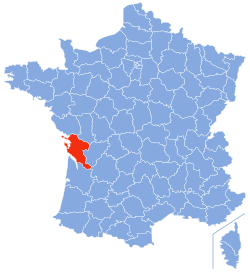
 Location of Charente-Maritime in France | |
| Coordinates: 45°57′N 0°58′W / 45.950°N 0.967°W | |
| Country | France |
| Region | Nouvelle-Aquitaine |
| Prefecture | La Rochelle |
| Subprefectures | Jonzac Rochefort Saintes Saint-Jean-d'Angély |
| Government | |
| • President of the Departmental Council | Sylvie Marcilly[1] (DVD) |
| Area | |
• Total | 6,864 km2 (2,650 sq mi) |
| Population (2021)[2] | |
• Total | 661,404 |
| • Rank | 40th |
| • Density | 96/km2 (250/sq mi) |
| Time zone | UTC+1 (CET) |
| • Summer (DST) | UTC+2 (CEST) |
| Area code | FR-17 |
| Department number | 17 |
| Arrondissements | 5 |
| Cantons | 27 |
| Communes | 463 |
| ^1 French Land Register data, which exclude estuaries and lakes, ponds and glaciers larger than 1 km2 | |
Charente-Maritime (French pronunciation: [ʃaʁɑ̃t maʁitim] ; Poitevin-Saintongeais: Chérente-Marine; Occitan: Charanta Maritima) is a département in the Nouvelle-Aquitaine region on the southwestern coast of France. Named after the river Charente, its prefecture is La Rochelle. As of 2019, it had a population of 651,358 with an area of 6,864 square kilometres (2,650 sq mi).[3]
- ^ "Répertoire national des élus: les conseillers départementaux". data.gouv.fr, Plateforme ouverte des données publiques françaises (in French). 4 May 2022.
- ^ "Téléchargement du fichier d'ensemble des populations légales en 2021" (in French). The National Institute of Statistics and Economic Studies. 28 December 2023.
- ^ "Comparateur de territoires − Département de la Charente-Maritime (17) | Insee". www.insee.fr. Retrieved 9 July 2022.

