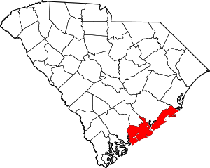
Charleston County | |
|---|---|
 Location within the U.S. state of South Carolina | |
 South Carolina's location within the U.S. | |
| Coordinates: 32°48′N 79°56′W / 32.80°N 79.94°W | |
| Country | |
| State | |
| Founded | January 1, 1800 |
| Named for | King Charles II |
| Seat | Charleston |
| Largest community | Charleston |
| Area | |
• Total | 1,357.99 sq mi (3,517.2 km2) |
| • Land | 917.98 sq mi (2,377.6 km2) |
| • Water | 440.01 sq mi (1,139.6 km2) 32.40% |
| Population (2020) | |
• Total | 408,235 |
• Estimate (2023) | 424,367 |
| • Density | 444.71/sq mi (171.70/km2) |
| Time zone | UTC−5 (Eastern) |
| • Summer (DST) | UTC−4 (EDT) |
| Congressional districts | 1st, 6th |
| Website | www |
Charleston County is located in the U.S. state of South Carolina along the Atlantic coast. As of the 2020 census, the population was 408,235,[1] making it the third-most populous county in South Carolina (behind Greenville and Richland counties). Its county seat is Charleston.[2] It is also the largest county in the state by total area, although Horry County has a larger land area. The county was created in 1800 by an act of the South Carolina State Legislature.[3]
Charleston County is included in the Charleston-North Charleston, SC Metropolitan Statistical Area. It is in the Lowcountry region of South Carolina.
- ^ Cite error: The named reference
2020CensusQuickFactswas invoked but never defined (see the help page). - ^ "Find a County". National Association of Counties. Archived from the original on May 31, 2011. Retrieved June 7, 2011.
- ^ "Charleston County, South Carolina". www.carolana.com. Retrieved June 13, 2022.


