| Charly River | |
|---|---|
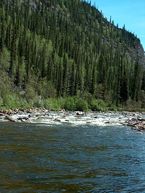
 Flowing through Yukon–Charley Rivers National Preserve | |
| Location | |
| Country | United States |
| State | Alaska |
| Census Area | Southeast Fairbanks, Yukon–Koyukuk |
| Physical characteristics | |
| Source | Mertie Mountains |
| • location | Yukon–Charley Rivers National Preserve, Southeast Fairbanks Census Area |
| • coordinates | 64°42′15″N 144°02′41″W / 64.70417°N 144.04472°W[1] |
| • elevation | 4,023 ft (1,226 m)[2] |
| Mouth | Yukon River |
• location | 55 miles (89 km) northwest of Eagle, Yukon–Koyukuk Census Area |
• coordinates | 65°19′02″N 142°46′50″W / 65.31722°N 142.78056°W[1] |
• elevation | 686 ft (209 m)[1] |
| Length | 88 mi (142 km)[1] |
| Type | Wild 208.0 miles (334.7 km) |
| Designated | December 2, 1980[3] |
The Charley River is an 88-mile (142 km) tributary of the Yukon River in the U.S. state of Alaska.[1] Flowing generally northeast from the Mertie Mountains (named after geologist John Beaver Mertie, Jr.) in the northeastern part of the state, the river lies entirely within Yukon–Charley Rivers National Preserve.[4] The Charley River enters the larger river downstream and 55 miles (89 km) northwest of Eagle.[1]
In 1980, the Charley River and all of its main tributaries became part of the National Wild and Scenic Rivers System.[5] A total of 208 miles (335 km) was declared "wild" along the entire main stem as well as Copper, Bonanza, Hosford, Derwent, Flat-Orthmer, Crescent, and Moraine creeks.[5]
The Charley River watershed is forested chiefly with black spruce and white spruce.[6] This general locus within the Yukon River catchment is the approximate westernmost limit of the black spruce, Picea mariana.[7] The river forms part of the boundary between the Southeast Fairbanks and Yukon–Koyukuk census areas.
- ^ a b c d e f "Charley River". Geographic Names Information System. United States Geological Survey. January 1, 2000. Retrieved November 6, 2013.
- ^ Derived by entering source coordinates in Google Earth.
- ^ "National Wild and Scenic Rivers System". rivers.gov. National Wild and Scenic Rivers System. Retrieved 2023-01-05.
- ^ Alaska Atlas & Gazetteer (7th ed.). Yarmouth, Maine: DeLorme. 2010. pp. 118, 128. ISBN 978-0-89933-289-5.
- ^ a b "Charley River, Alaska". National Wild and Scenic Rivers. Retrieved November 7, 2013.
- ^ J.G. Clough et al. 1995
- ^ C. Michael Hogan. 2008
