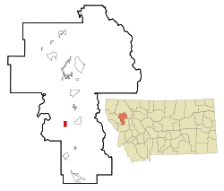
Charlo, Montana | |
|---|---|
 | |
 Location of Charlo, Montana | |
| Coordinates: 47°26′24″N 114°10′23″W / 47.44000°N 114.17306°W | |
| Country | United States |
| State | Montana |
| County | Lake |
| Area | |
• Total | 2.00 sq mi (5.19 km2) |
| • Land | 1.99 sq mi (5.16 km2) |
| • Water | 0.01 sq mi (0.03 km2) |
| Elevation | 2,936 ft (895 m) |
| Population (2020) | |
• Total | 385 |
| • Density | 193.37/sq mi (74.64/km2) |
| Time zone | UTC-7 (Mountain (MST)) |
| • Summer (DST) | UTC-6 (MDT) |
| ZIP code | 59824 |
| Area code | 406 |
| FIPS code | 30-13900 |
| GNIS feature ID | 0769768 |
Charlo (Salish: sallu[2]) is an unincorporated community and census-designated place (CDP) in Lake County, Montana, United States. The population was 385 at the 2020 census.[3]
The town was named in 1918 after the Salish leader Chief Charlo.[4] Previously it had been called Big Flat, Charlotte, and Tabor.[4]
- ^ "ArcGIS REST Services Directory". United States Census Bureau. Retrieved September 5, 2022.
- ^ Tachini, Pete (2010). Seliš nyoʻnuntn, Medicine for the Salish language : English to Salish translation dictionary (2nd ed.). Pablo, MT: Salish Kootenai College Press. p. 109. ISBN 9781934594063.
- ^ "Charlo CDP, Montana". United States Census Bureau. Retrieved September 18, 2023.
- ^ a b "Charlo". Montana Place Names Companion. Montana Historical Society. Retrieved April 2, 2021.