Chatham, New Hampshire | |
|---|---|
Town | |
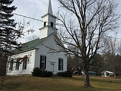
 Chatham Congregational Church in Chatham village | |
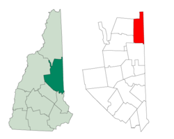
 Location in Carroll County, New Hampshire | |
| Coordinates: 44°09′49″N 71°00′40″W / 44.16361°N 71.01111°W | |
| Country | United States |
| State | New Hampshire |
| County | Carroll |
| Incorporated | 1767 |
| Villages |
|
| Government | |
| • Board of Selectmen |
|
| Area | |
| • Total | 57.3 sq mi (148.3 km2) |
| • Land | 56.7 sq mi (146.9 km2) |
| • Water | 0.5 sq mi (1.4 km2) 0.96% |
| Elevation | 521 ft (159 m) |
| Population (2020)[2] | |
| • Total | 341 |
| • Density | 6.0/sq mi (2.3/km2) |
| Time zone | UTC-5 (Eastern) |
| • Summer (DST) | UTC-4 (Eastern) |
| ZIP code | 03813 |
| Area code | 603 |
| FIPS code | 33-11780 |
| GNIS feature ID | 0873563 |
| Website | chathamnh |
Chatham is a town in Carroll County, New Hampshire, United States. The population was 341 at the 2020 census.[2] It is located in the White Mountains, and except for the southeastern corner, all of Chatham is in the White Mountain National Forest. The town is home to the Cold River national forest campgrounds.
- ^ "2020 U.S. Gazetteer Files – New Hampshire". United States Census Bureau. Retrieved October 29, 2021.
- ^ a b "Chatham town, Carroll County, New Hampshire: 2020 DEC Redistricting Data (PL 94-171)". U.S. Census Bureau. Retrieved October 29, 2021.