Chaubunagungamaug Reservation | |
|---|---|
State Indian Reservation | |
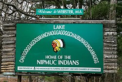
 Sign with the 14-syllable long form alternate name for Lake Chaubunagungamaug that also acknowledges the Nipmuck presence in the town. | |
 The Town of Webster, which contained the original reservation, within Worcester County and the Commonwealth of Massachusetts underneath the Town Seal. | |
| Coordinates: 42°01′27″N 71°52′38″W / 42.02417°N 71.87722°W | |
| Country | United States |
| State | Massachusetts |
| County | Worcester |
| Praying Town of Chabanakongkomun | 1674-1675[1] |
| Dudley Indian (Chaubunagungamaug) Reservation | c. 1682-1887[2] |
| Chaubungaungmaug Reservation | 1981–present[3] |
| Government | |
| • Type | Council meeting, with members elected from certain family lines. |
| • Sachem | Edwin Spring Fox Morse III |
| Area | |
| • Total | 2.5[3] acres (1.0 ha) |
| Elevation | 506 ft (154 m) |
| Population (2010) | |
| • Total | 0 |
| • Density | 0.0/sq mi (0.0/km2) |
| Time zone | UTC-5 (Eastern) |
| • Summer (DST) | UTC-4 (Eastern) |
| ZIP code | 01570 |
| Area code | 508 / 774 |
| Website | Official CBNI Website |
The Chaubunagungamaug Reservation refers to the small parcel of land located in the town of Thompson, Connecticut, close to the border with the town of Webster, Massachusetts, and within the bounds of Lake Chaubunagungamaug (Webster Lake) to the east and the French River to the west. The reservation is used by the descendants of the Nipmuck Indians of the previous reservation, c. 1682–1869, that existed in the same area, who now identify as the Webster/Dudley Band of the Chaubunagungamaug Nipmuck.[4]
The reservation only consists of 2.5 acres (1.0 hectare), and does not support a permanent population. It does serve as a meeting place and cultural center for Webster/Dudley Band of the Chaubunagungamaug Nipmuck. The land is also used as a place for the reinterment of local Native American remains.[5] The tribe, and its reservation, are recognized in Massachusetts, but both lack recognition in Connecticut and at the federal level.[6][7]
- ^ Cogley, R. W. (1999). John Eliot's Mission to the Indians Before King Philip's War. (pp. 156-166) Cambridge, MA: Harvard University Press.
- ^ McCaleb, N. A. (2001). Summary under the Criteria and Evidence for Proposed Finding VebsterlDudley Band of Chaubunagungamaug Nipmuck Indians Archived 2014-06-09 at the Wayback Machine. (CBN-V001-D005) (United States, Department of the Interior, BIA Office of Federal Acknowledgment). pp. 34, 74.
- ^ a b McCaleb, N. A. (2001). pp. 88-90.
- ^ Executive Office of Housing and Economic Development, Commission on Indian Affairs. (n.d.). Tuition waiver guidelines. Retrieved from Commonwealth of Massachusetts website: www.mass.gov/hed/docs/dhcd/ia/tuitionwaiver.doc. [dead link]
- ^ Kotyk, P. (2005–14) "Who are the Nipmuck Native Americans that lived along the Assabet River?" The Story of the Pine Hawk. Acton, MA: Acton-Boxborough Public Schools.
- ^ Blumenthal, R. Connecticut Department of Justice, Office of the Attorney General. (2002). "Comments of the State of Connecticut and the Northeastern Connecticut Council of Governments on the Proposed Findings on the Petitions for Tribal Acknowledgement of the Nipmuc Nation and the Webster/Dudley Band of the Chaubunagungamaug Nipmuck Indians". Retrieved August 22, 2016. Archived September 18, 2016, at the Wayback Machine
- ^ Martin, A. M. (2004). Summary under the Criteria and Evidence for Final Determination against Federal Acknowledgment of the Webster/Dudley Band of Chaubunagungamaug Nipmuck Indians Archived 2016-03-24 at the Wayback Machine (CBN-V001-D007) (United States, Department of Interior, BIA Office of Federal Acknowledgment). p. 57.