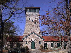
| Cheaha State Park | |
|---|---|
 Bunker Tower | |
| Location | Clay County and Cleburne County, Alabama, United States |
| Coordinates | 33°29′07″N 85°48′30″W / 33.48528°N 85.80833°W[1] |
| Area | 2,799 acres (1,133 ha) |
| Elevation | 2,405 ft (733 m)[1] |
| Established | 1933 |
| Administered by | Alabama Department of Conservation and Natural Resources |
| Website | Official website |
Cheaha State Park is a public recreation area located in Clay and Cleburne counties in Alabama, US. The park's 2,799 acres (1,133 ha) include Cheaha Mountain, the highest point in the state. The park adjoins Talladega National Forest and is managed by the Alabama Department of Conservation and Natural Resources. It is Alabama's oldest continuously operating state park.[2] Facilities include lodgings, a restaurant, campsites, and hiking trails.[3]
- ^ a b "Cheaha Mountain". Geographic Names Information System. United States Geological Survey, United States Department of the Interior.
- ^ Cite error: The named reference
encyclopediawas invoked but never defined (see the help page). - ^ Cite error: The named reference
statewas invoked but never defined (see the help page).
