| Cheero Point Central Coast, New South Wales | |||||||||||||||
|---|---|---|---|---|---|---|---|---|---|---|---|---|---|---|---|
 | |||||||||||||||
 | |||||||||||||||
| Coordinates | 33°30′40″S 151°11′38″E / 33.511°S 151.194°E | ||||||||||||||
| Population | 87 (2016 census)[1] | ||||||||||||||
| Postcode(s) | 2083 | ||||||||||||||
| Elevation | 6 m (20 ft) | ||||||||||||||
| Location | |||||||||||||||
| LGA(s) | Central Coast Council | ||||||||||||||
| Parish | Cowan[2] | ||||||||||||||
| State electorate(s) | Gosford | ||||||||||||||
| Federal division(s) | Robertson | ||||||||||||||
| |||||||||||||||
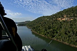
Cheero Point is a waterfront locality and suburb of the Central Coast region of New South Wales, Australia. Cheero Point is located on the west bank of the Mooney Mooney Creek in the Brisbane Water National Park. It is situated 53 kilometres (33 mi) north of Sydney. It is part of the Central Coast Council local government area.
- ^ Australian Bureau of Statistics (27 June 2017). "Cheero Point (State Suburb)". 2016 Census QuickStats. Retrieved 10 November 2019.
- ^ "Cheero Point (Suburb)". Geographical Names Register (GNR) of NSW. Geographical Names Board of New South Wales. Retrieved 16 July 2007.
