Cherat چېراټ | |
|---|---|
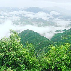
 Cherat after the summer monsoon rains | |
| Coordinates: 33°29′N 71°32′E / 33.49°N 71.53°E | |
| Country | |
| Province | Khyber-Pakhtunkhwa |
| District | Nowshera District |
| Elevation | 892 m (2,927 ft) |
| Time zone | UTC+5 (PST) |
Cherat (Pashto: چېراټ) is a hill station dating from the 1860s that is located immediately above the villages of Chapri,Bakhti, Saleh Khana, Kotli Kalan and Dak Ismail Khel in the Nowshera District of Khyber-Pakhtunkhwa in Pakistan. Cherat lies 34 miles south east from the city of Peshawar at an elevation of 4,500 feet on the west of the Khattak range, which divides the district of Nowshera from Kohat District.[1]
- ^ One or more of the preceding sentences incorporates text from a publication now in the public domain: Chisholm, Hugh, ed. (1911). "Cherat". Encyclopædia Britannica. Vol. 6 (11th ed.). Cambridge University Press. p. 82.
