Cherokee, California | |
|---|---|
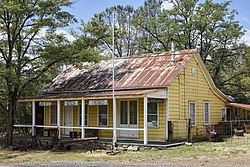
 The Cherokee Museum | |
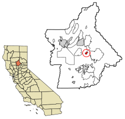
 Location of Cherokee in Butte County, California. | |
| Coordinates: 39°38′47″N 121°32′18″W / 39.64639°N 121.53833°W | |
| Country | United States |
| State | California |
| County | Butte County |
| Area | |
• Total | 1.922 sq mi (4.976 km2) |
| • Land | 1.751 sq mi (4.534 km2) |
| • Water | 0.171 sq mi (0.442 km2) 8.9% |
| Elevation | 1,306 ft (398 m) |
| Population | |
• Total | 88 |
| • Density | 46/sq mi (18/km2) |
| Time zone | UTC-8 (Pacific) |
| • Summer (DST) | UTC-7 (PDT) |
| ZIP code | 95965 |
| Area code | 530 |
| GNIS feature IDs | 1655889, 2612476 |
| U.S. Geological Survey Geographic Names Information System: Cherokee, California; U.S. Geological Survey Geographic Names Information System: Cherokee, California | |
Cherokee is an unincorporated community and census-designated place[4] in Butte County, California. It is an area inhabited by Maidu Indians prior to the gold rush, but that takes its name from a band of Cherokee prospectors who perfected a mining claim on the site. The population was 69 at the 2010 census. It lies at an elevation of 1306 feet (398 m).
Possibly the site of the historic gold mine, on the 1994 Cherokee, California 7.5-minute quadrangle, a feature named "Cherokee Placer Mine" exists about 0.65 miles southwest of the above coordinates. USGS identifies Cherokee Flat and Drytown as historic variant names for the community. The town is located on Cherokee Road off State Route 70.
Today, Cherokee now consists of a museum and a Cherokee cemetery, as well as a few houses. The Cherokee Heritage and Museum Association maintains both.
The ZIP Code is 95965. The community is inside area code 530.
- ^ "2010 Census U.S. Gazetteer Files – Places – California". United States Census Bureau.
- ^ "Cherokee". Geographic Names Information System. United States Geological Survey, United States Department of the Interior. Retrieved February 4, 2015.
- ^ "Explore Census Data". data.census.gov. Retrieved June 29, 2023.
- ^ "Cherokee Census Designated Place". Geographic Names Information System. United States Geological Survey, United States Department of the Interior. Retrieved February 4, 2015.
