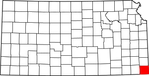
Cherokee County | |
|---|---|
 Tri-State Marker (2006) | |
 Location within the U.S. state of Kansas | |
 Kansas's location within the U.S. | |
| Coordinates: 37°10′N 94°51′W / 37.167°N 94.850°W | |
| Country | |
| State | |
| Founded | February 18, 1860 |
| Named for | Cherokee Native Americans |
| Seat | Columbus |
| Largest city | Baxter Springs |
| Area | |
| • Total | 591 sq mi (1,530 km2) |
| • Land | 588 sq mi (1,520 km2) |
| • Water | 3.5 sq mi (9 km2) 0.6% |
| Population | |
| • Total | 19,362 |
| • Density | 32.9/sq mi (12.7/km2) |
| Time zone | UTC−6 (Central) |
| • Summer (DST) | UTC−5 (CDT) |
| Area code | 620 |
| Congressional district | 2nd |
| Website | cherokeecountyks.gov |
Cherokee County is a U.S. county located in Southeast Kansas. Its county seat is Columbus,[2] and its most populous city is Baxter Springs. As of the 2020 census, the county population was 19,362.[1] The county was named for the Cherokee tribe.
- ^ a b "QuickFacts; Cherokee County, Kansas; Population, Census, 2020 & 2010". United States Census Bureau. Archived from the original on August 15, 2021. Retrieved August 15, 2021.
- ^ "Find a County". National Association of Counties. Archived from the original on May 9, 2015. Retrieved June 7, 2011.