| Chesapeake Bay impact crater | |
|---|---|
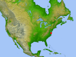
 Location of impact site in relation to North America | |
| Impact crater/structure | |
| Confidence | Confirmed |
| Diameter | 53 miles (85 km) |
| Depth | 0.81 miles (1.3 km) |
| Impactor diameter | 1.9 miles (3 km) |
| Age | 35.5 ± 0.3 million |
| Exposed | No |
| Drilled | Yes |
| Bolide type | L chondrite[1] |
| Location | |
| Location | Chesapeake Bay |
| Coordinates | 37°17′N 76°1′W / 37.283°N 76.017°W[2] |
| Country | United States |
| State | Virginia |
| Municipality | Cape Charles |
| Access | U.S. Route 13 to S.R. 184 |
The Chesapeake Bay impact crater is a buried impact crater, located beneath the mouth of Chesapeake Bay, United States. It was formed by a bolide that struck the eastern shore of North America about 35.5 ± 0.3 million years ago, in the late Eocene epoch. It is one of the best-preserved "wet-target" impact craters in the world.[3]
Continued slumping of sediments over the rubble of the crater has helped shape the Chesapeake Bay.
- ^ Schmitz, Birger; Boschi, Samuele; Cronholm, Anders; Heck, Philipp R.; Monechi, Simonetta; Montanari, Alessandro; Terfelt, Fredrik (2015). "Fragments of Late Eocene Earth-impacting asteroids linked to disturbance of asteroid belt" (PDF). Earth and Planetary Science Letters. 425: 77–83. Bibcode:2015E&PSL.425...77S. doi:10.1016/j.epsl.2015.05.041. ISSN 0012-821X.
- ^ "Chesapeake Bay". Earth Impact Database. Planetary and Space Science Centre University of New Brunswick Fredericton. Retrieved 15 September 2019.
- ^ "Chesapeake Bay impact structure: Morphology, crater fill, and relevance for impact structures on Mars". USGS. United States Geological Survey. 2006. Retrieved 5 March 2019.
