Chesterfield, Missouri | |
|---|---|
 From top left: Butterfly House, Faust Park, Residential area, Old Chesterfield | |
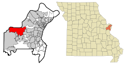
 Location of Chesterfield, Missouri | |
| Coordinates: 38°39′32″N 90°34′49″W / 38.65889°N 90.58028°W | |
| Country | United States |
| State | Missouri |
| County | St. Louis |
| Incorporated | 1988 |
| Government | |
| • Mayor | Bob Nation[1] |
| Area | |
• Total | 33.84 sq mi (87.64 km2) |
| • Land | 31.84 sq mi (82.45 km2) |
| • Water | 2.00 sq mi (5.19 km2) |
| Elevation | 515 ft (157 m) |
| Population | |
• Total | 49,999 |
| • Density | 1,570.57/sq mi (606.40/km2) |
| Time zone | UTC−6 (Central (CST)) |
| • Summer (DST) | UTC−5 (CDT) |
| Zip code | 63005, 63017 |
| Area code(s) | 314, 636 |
| FIPS code | 29-13600[5] |
| GNIS feature ID | 2393821[3] |
| Website | chesterfield.mo.us |
| [6] | |
Chesterfield is a city in St. Louis County, Missouri, United States. It is a western suburb of St. Louis. As of the 2020 census, the population was 49,999,[4] making it the state's 14th most populous city. The broader valley of Chesterfield was originally referred to as "Gumbo Flats", derived from its soil, which though very rich and silty, resembled gumbo when wet.
- ^ "Mayor's Office". Chesterfield, Missouri. City of Chesterfield, Missouri. Retrieved May 5, 2015.
- ^ "ArcGIS REST Services Directory". United States Census Bureau. Retrieved August 28, 2022.
- ^ a b U.S. Geological Survey Geographic Names Information System: Chesterfield, Missouri
- ^ a b "U.S. Census website". census.gov. United States Census Bureau. Retrieved January 30, 2021.
- ^ "U.S. Census website". United States Census Bureau. Retrieved January 31, 2008.
- ^ "US Gazetteer files: 2010, 2000, and 1990". United States Census Bureau. February 12, 2011. Retrieved April 23, 2011.