| Chestfield | |
|---|---|
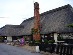
 Chestfield Barn | |
Location within Kent | |
| Area | 7.94 km2 (3.07 sq mi) |
| Population | 3,214 (Civil Parish 2011)[1] |
| • Density | 405/km2 (1,050/sq mi) |
| OS grid reference | TR132657 |
| Civil parish |
|
| District | |
| Shire county | |
| Region | |
| Country | England |
| Sovereign state | United Kingdom |
| Post town | WHITSTABLE |
| Postcode district | CT5 |
| Dialling code | 01227 |
| Police | Kent |
| Fire | Kent |
| Ambulance | South East Coast |
| UK Parliament | |
Chestfield is a village (and civil parish and with Swalecliffe a district council ward) in the Canterbury District of Kent, England. The parish is centred 0.5 miles (0.80 km) from the sea on the north coast of Kent, between the towns of Whitstable and Herne Bay. It is approximately five miles (8 km) north of Canterbury. Over a third of the parish, all of which is the south of its ambit, is woodland. The north-west consists of a business park and superstore.
- ^ Key Statistics; Quick Statistics: Population Density Archived 11 February 2003 at the Wayback Machine United Kingdom Census 2011 Office for National Statistics Retrieved 21 November 2013
