| Chew Valley Reservoir | |
|---|---|
 | |
 Chew Valley Reservoir | |
| Location | Greater Manchester |
| Coordinates | 53°31′N 1°57′W / 53.51°N 1.95°W |
| Type | Reservoir |
| Primary inflows | Chew Clough, Green Grain, Dry Clough, South Clough |
| Primary outflows | Chew Brook |
| Basin countries | United Kingdom |
Chew Valley in Saddleworth, Greater Manchester, England,[1] follows the course of Chew Brook on the western slopes of Black Chew Head to where it joins the River Tame at Greenfield, east of Manchester. Part of the higher fringes of the valley towards the peak of Black Chew Head lie across the boundary in Derbyshire. The eastern part of the valley including the reservoirs of Dovestone and Chew are within the north western extremity of the Peak District National Park.
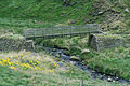
Chew Reservoir was completed in 1912. At 1,600 feet (490 m) above sea level, it was the highest reservoir constructed in England. A tram-road was laid in Chew Valley to transport 42,318 cubic yards (32,354 m3) of clay to make an inner core for its dam to make it watertight. The tram and railway are gone but the route forms the Oldham Way long-distance footpath; reconstructed bridge hosts a sign with information, pictures, and a map.
In 1949, a BEA Douglas DC3 crashed into the hill at Wimberry Rocks killing 24 passengers and crew and leaving 8 survivors.[2]
-
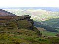 Wimberry Rocks in the Chew Valley
 -
 Sign showing ownership of the valley by United Utilities and old maps of the tram that once ran through the valley
 -
 Oldham Way footpath, Chew Valley


- ^ Ordnance Survey: Landranger map sheet 110 Sheffield & Huddersfield (Glossop & Holmfirth) (Map). Ordnance Survey. 2012. ISBN 9780319231876.
- ^ "Accident Description". Aviation Safety Network. Retrieved 15 June 2016.