This article needs additional citations for verification. (December 2014) |
Cheyenne River Indian Reservation | |
|---|---|
 Farmland on the reservation | |
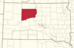
 Location in South Dakota | |
| Coordinates: 45°04′35″N 101°13′33″W / 45.07639°N 101.22583°W | |
| Tribe | Cheyenne River Sioux Tribe |
| Country | United States |
| State | South Dakota |
| Counties | Dewey Haakon Meade Stanley Ziebach |
| Established | 1889 |
| Government | |
| • Governing body | General Tribal Council |
| Area | |
• Total | 11,051.447 km2 (4,266.987 sq mi) |
| Population (2010)[1] | |
• Total | 8,090 |
| Time zone | UTC-7 (MST) |
| • Summer (DST) | UTC-6 (MDT) |
| GDP | $154.8 Million (2018) |
| Website | cheyenneriversioux.com |
The Cheyenne River Indian Reservation was created by the United States in 1889 by breaking up the Great Sioux Reservation, following the attrition of the Lakota in a series of wars in the 1870s. The reservation covers almost all of Dewey and Ziebach counties in South Dakota. In addition, many small parcels of off-reservation trust land are located in Stanley, Haakon, and Meade counties.
The total land area is 4,266.987 sq mi (11,051.447 km2), making it the fourth-largest Indian reservation in land area in the United States. Its largest community is unincorporated North Eagle Butte, while adjacent Eagle Butte is its largest incorporated city.
- ^ "2010 Census Summary File 1: Cheyenne River Reservation and Off-Reservation Trust Land, SD". American FactFinder. United States Census Bureau. Archived from the original on February 13, 2020. Retrieved June 29, 2018.