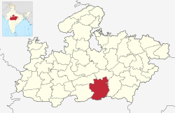
Chhindwara district
= छिंदवाड़ा मध्य प्रदेश का 5वां विकसित शहर है | |
|---|---|
District | |
 Location of Chhindwara district in Madhya Pradesh | |
| Country | |
| State | Madhya Pradesh |
| Division | Jabalpur |
| Established | 1 November 1956[1] |
| Headquarters | Chhindwara |
| Tehsils | 11 |
| Government | |
| • Lok Sabha constituencies | Chhindwara |
| Area | |
| • Total | 10,293 km2 (3,974 sq mi) |
| Population (2011) | |
| • Total | 1,716,612 |
| • Density | 170/km2 (430/sq mi) |
| Demographics | |
| • Literacy | 72.21% |
| • Sex ratio | 966 |
| Time zone | UTC+05:30 (IST) |
| Major highways | 47, 347, 547 |
| Website | chhindwaranagarnigam |

Chhindwara district is one of the major districts of Madhya Pradesh state of India, and Chhindwara town is the district headquarters. Chhindwara was the largest district in Madhya Pradesh with an area of 10,293 square km before the bifurcation of Pandhurna district. The district is part of Jabalpur division.
The name Chhindwara has been derived from the word Chhind, the local name of a tree found commonly in the district. Chhindwara district was formed on 1 November 1956.[1]
It is on the southwest region of the Satpura Range.[1] It is spread from 21.28 to 22.49 deg. North (latitude) and 78.40 to 79.24 deg. East (longitude) and spread over an area of 11,815 km2. This district is bound by the plains of Pandhurna district and Nagpur district (in Maharashtra State) on the south, Narmadapuram and Narsinghpur districts on the north, Betul district on the west and Seoni district on the east.[1]

