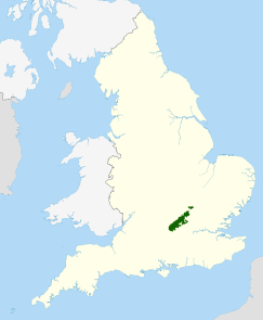
| Chiltern Hills | |
|---|---|
 Near Nettlebed, Oxfordshire | |
| Highest point | |
| Peak | Haddington Hill |
| Elevation | 267 m (876 ft) |
| Dimensions | |
| Length | 74 km (46 mi) |
| Width | 18 km (11 mi) |
| Area | 1,700 km2 (660 sq mi) |
| Geography | |
| Location | Southeast of England East of England |
| Country | United Kingdom |
| Counties | Bedfordshire Buckinghamshire Hertfordshire Oxfordshire |
| Range coordinates | 51°40′N 0°55′W / 51.667°N 0.917°W |
| Geology | |
| Rock type | chalk downland |
The Chiltern Hills or the Chilterns are a chalk escarpment in southern England,[1] northwest of London, covering 660 square miles (1,700 km2) across Oxfordshire, Buckinghamshire, Hertfordshire, and Bedfordshire, stretching 45 miles (72 km) from Goring-on-Thames in the southwest to Hitchin in the northeast. The hills are 12 miles (19 km) at their widest.
In 1965, almost half of the Chilterns was designated as an Area of Outstanding Natural Beauty (AONB). The northwest boundary is clearly defined by the escarpment. The dip slope is by definition more gradual, and merges with the landscape to the southeast.[2] The southwest endpoint is the River Thames. The hills decline slowly in prominence in northeast Bedfordshire.[3][4]
- ^ Chisholm, Hugh, ed. (1911). . Encyclopædia Britannica. Vol. 6 (11th ed.). Cambridge University Press. p. 163.
- ^ Cite error: The named reference
HeppleDoggettwas invoked but never defined (see the help page). - ^ The Changing Landscape of the Chilterns Archived 3 March 2016 at the Wayback Machine Chilterns AoNB, Accessed 19 February 2012
- ^ Chiltern Society, The Chilterns Archived 7 September 2011 at the Wayback Machine.
