| Chilton Foliat | |
|---|---|
 | |
Location within Wiltshire | |
| Population | 363 (in 2011)[1] |
| OS grid reference | SU321704 |
| Civil parish |
|
| Unitary authority | |
| Ceremonial county | |
| Region | |
| Country | England |
| Sovereign state | United Kingdom |
| Post town | Hungerford |
| Postcode district | RG17 |
| Dialling code | 01488 |
| Police | Wiltshire |
| Fire | Dorset and Wiltshire |
| Ambulance | South Western |
| UK Parliament | |
| Website | www |

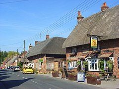
Chilton Foliat is a village and civil parish on the River Kennet in Wiltshire, England. The parish is in the North Wessex Downs Area of Outstanding Natural Beauty. It is on the county boundary with West Berkshire and is about 1.5 miles (2.4 km) northwest of the Berkshire market town of Hungerford.
The village is on the B4192 Hungerford-Swindon road, which was the A419 until 1977, when it was redesignated after the opening of the M4 motorway.[2] The parish includes the hamlets of Straight Soley and Crooked Soley.
- ^ "Wiltshire Community History – Census". Wiltshire Council. Retrieved 17 October 2014.
- ^ Crowley, D.A. (ed.). "Victoria County History – Wiltshire – Vol 16 pp88-109 – Chilton Foliat". British History Online. University of London. Retrieved 3 April 2016.
