This article needs additional citations for verification. (April 2012) |
| National Highway 109 | ||||
|---|---|---|---|---|
| 109国道 | ||||
 | ||||
| Route information | ||||
| Part of | ||||
| Length | 3,901 km (2,424 mi) | |||
| Major junctions | ||||
| From | Beijing | |||
| To | Lhasa | |||
| Location | ||||
| Country | China | |||
| Highway system | ||||
| ||||
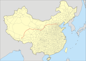
China National Highway 109 connects Beijing with Lhasa. It runs westwards from Beijing via Datong, Yinchuan and Xining to Golmud before turning southwest to Lhasa. The portion of the highway from Xining to Lhasa is known as the Qinghai-Tibet Highway.[1] The total length of the route is 3,901 km.
Fushi Road or Jinglan Road forms the stretch of G109 in Beijing, as it begins from Fuchengmen and traverses through Shijingshan. The majority of the Beijing section is in Mentougou District.
The section of the highway within western Qinghai and Tibet, from Golmud to Lhasa, is paralleled by the Qinghai-Tibet Railway. The highway reaches its highest elevation of 5,231 meters (17,162 ft) at Tanggula Pass. Construction of this section started on 11 May 1954.[2]
"Tasked with carrying upwards of 85 per cent of goods in and out of Tibet, the Qinghai-Tibet Highway has been dubbed the "Lifeline of Tibet." ... Since it was opened to traffic in 1954, the central government has spent nearly 3 billion yuan (US$362 million) on three major overhauls. It was asphalted in 1985."[3]
The route also holds importance as one of the main coal transport routes in southern Inner Mongolia.[4]
- ^ Caidan, Ann; Jun, Liu; Jinhui, Li; Tao, Xie (2003). Tibet China: travel guide. China Intercontinental Press. pp. 160–161. ISBN 9787508503745.
- ^ 王宗仁 (2001-10-01). 苍茫青藏 (in Chinese). Beijing Book Co. Inc. ISBN 978-7-5065-4113-8.
- ^ Gyaco, Former director of the Communications Commission of the Tibet Autonomous Region (2005-01-05). "Roads of change revitalize Tibet". Asia Africa Intelligence Wire, Business Daily Update. Retrieved 2012-04-07.
- ^ "保证司乘安全 国道109线4座大型桥梁定期检测-内蒙古新闻-中国新闻网". www.nmg.chinanews.com. Retrieved 2021-06-04.
